[ Log In ] or [ Register ]

Shoal Creek

Trail (2.87)16
(1.59) (1.47)
4.40 Miles N/A
N/A No
Yes Yes
Free More Info
Austin Travis
Take Action Bookmark and Share

Getting there: We suggest starting from the northern end of the trail. The parking is easier and some of the nicer portions of the trail are in the northern half. We parked in the Randall's supermarket parking lot on 35th Street, right next to Shoal Creek. There was plenty of parking and the section of the parking lot closest to the creek was completely empty.

The Hike: Shoal Creek offers some interesting contrasts in the heart of Austin. At times the creek resembles little more than a drainage ditch. At other times it's hard to believe that you're in the center of the city.
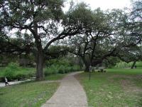
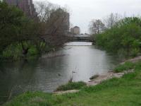
Seiders Oaks
Our hike started at the waypoint marked "Trailhead" next to Randall's supermarket on 35th street. You need not go far in order to see the first interesting section of trail. This section is known as Seiders Springs Park. Almost immediately you will see a stand of Oak trees called Seiders Oaks. In 1839 Gideon White built a home here only to die in an Indian massacre in 1842. White's daughter, Louisa, wed Edward Seiders in 1846.

Edward was an enterprising fellow and saw an opportunity in the springs that gushed from the rock face on the opposite bank from these oaks. He built a small resort here after constructing pools to collect the clear, cool waters. Some of those pools exist to this day and we were fortunate to come by during a wet period when the springs were active.

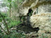
One of Seiders springs
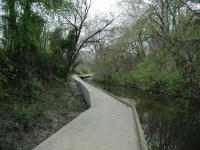
The Shoal Creek trail is fairly easy to navigate, but it does cross the creek several time down its length. Some crossings are easier than others. The crossing at Seiders Springs, to get to the side of the creek with the pools was easy. The cement walkway can even be traversed by wheelchair. The terrain of the trail varies greatly depending upon the section though. Some parts are paved concrete, some cushed gravel, some compacted dirt. In this regard it provides a bit more of a real "hiking" experience at times than the Town Lake hike and bike trail.

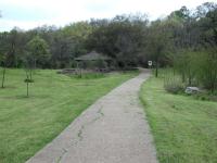
Much of Shoal Creek provides easy terrain
Some sections of the trail can not hug Shoal Creek closely because many old houses are built right up on the creek's banks. Waypoint "Exit Trail" marks on place in which you'll have to walk along 31st street for a couple of blocks until you get to waypoint "Enter Trail", when the trail rejoins the creek.

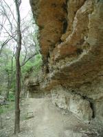
Watch out for some of these overhangs
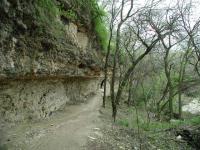
Now you're in one of the most interesting parts of the hike. The trail here enters a small canyon of rock and you could very well forget that you in the center of Austin. The rock overhangs are impressive and in one small section are low enough that you'll need to watch your head as you pass through. If you elect to only hike part of Shoal Creek, this is one area that you should include in your trip.

Once you exit the canyon the trail gets easier. On the opposite bank an impressive rock face remains, but it's largely flat and easy going on the trail side. When you get to waypoint "Shells" you'll see an interesting feature of Shoal Creek's beds. At the turns in the creek rocks and shells pile up. Many of those shells are actually fossils, reminders of a time when central Texas was ocean bottom instead of Hill Country. Remember that city ordinance prohibits the removal of fossils from city parks. Look all you want, but leave them for others to enjoy.

Probably the most interesting section of Shoal Creek
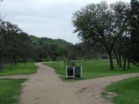
At waypoint "Pease Park" you have entered Pease Park. With the exception of a moderate hill the going is easy and the grounds well kept. You'll encounter many more people here as Pease Park is one of the more popular parks in central Austin.

Pease Park. Note the top of the capital poking out above the trees.
If you're not interested in continuing all the way to Town Lake waypoint "Pease End" may be a good time to turnaround. The trail south of here is not nearly as nice and often has no connection with nature to speak of. If you want park-like settings then spend your time north of 15th Street.

We're going to trace Shoal Creek to its end though, so we continue on and are rewarded the site of the old Austin Athletic Club building at waypoint "AAC". This building has been around since the 1930's and has stood abandoned since the late 1980's.

The trail at this point sometimes resembles a walkway adjancent to a drainage ditch. Every now and then a nice view, but often not very appealing visually. At waypoint "Building Supply Sign" though you can get a little gem of history. We found the back of the old Austin Building Supply, complete with painted sign that you can see here.

The southern section of Shoal Creek is not the best
Just south of the building supply sign is the last creek crossing that you'll have to make in this direction and it's the most tricky. We did not want to go up to street level further upstream and then work our way to the other side, so found the shallowest section of stream and positioned some rocks strategically so that we could hop across. The shallowest section was a couple of hundred feet away from the trail proper on the other side so we had to carefully walk along the decorative stone wall (stairsteped, thankfully) on the opposite bank.

The Seaholm power plant dominates the last couple of blocks before getting to Town Lake. Technically, some part of the trail should be off limits as construction goes on. When we got to waypoint "Gates" though we found the gates wide open and no one around, so we proceeded, knowing that the last stretch of trail was just a bit further up. We were rewarded by being able to pass by the remnants of a railroad bridge on 3rd street. Some of the rails had the date 1928 stamped on them.

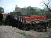
Yet more railroad track goes away
The fence on the opposite side of off limits area was closed, though someone had cut a sizable hole in it and people came and went as they please. One fellow even got through with his bicycle. Shoal Creek widens as it gets to Town Lake and makes a sharp left turn just before spilling into it.

Waypoint "Turnaround" was the end of our hike as we planned a two car effort so that we would not have to hike back due to time constraints. The total distance for our hike was 4.4 miles and we did this in 3 hours and 50 minutes. Of course we stopped and took photos and looked at fossils, which means you could very well complete the trip in a shorter period of time.

Shoal Creek turns, then empties into Town Lake
One complaint with the hike overall compared to some others is the amount of trash that we saw on the trail, particularly in brush along the creek itself. Given the fact that not much trash was on the trail or in the creek itself, it's likely that the trash was more a result of wash out from the surrounding city that got caught travelling downstream. When you go hiking be sure to bring at least a small bag into which to pick up a few items. Leave the trail in better shape than you found it. If we all did that there would be a remarkable improvement in the environment.


Photos

Shoal Creek Oak Tree Old oak trees are plentiful along Shoal Creek. (Photo by swedegirl5) Poor Pease Park! Unfortunately, this is a typical sight in Pease Park and along the Shoal Creek trail. (Photo by swedegirl5)

Log Entries

Good hike if you don't mind bikes and dogs
User: cwlatapie - 2/23/2013  [View Log Page]
Rating: Difficulty: Solitude:
Distance: 8.00 Miles Duration: 5 hours
Lots of bikes and Dogs. Pretty clean in most areas. Takes you right into downtown Austin, I like to hit a few spots before the hike back.
Trailhead at 38th to Pease Park
User: jar935 - 2/5/2013  [View Log Page]
Rating: Difficulty: Solitude:
Distance: 3.00 Miles Duration: N/A
Have walked this section before and enjoyed it. Decided to do a leisurely night hike and sit and read along the way (Kindle for iPhone--can now read in the dark! Hurrah!) Started right at sunset after eating a delicious cheeseburger at Top Notch burgers, spent a few hours strolling and reading. Used iPhone as a flashlight two or three times for creek crossings or uneven descents, just to be safe, but could have done without as terrain is all pretty easy. Very dark under bridges but I hummed a little tune as I approached so as to warn homeless people camping under them that I was coming. I did not want to shine a flashlight in their eyes so did not use it. Had to keep an eye out behind me for cyclists since I was not very visible and they were not expecting me, but all went quite smoothly and was very pleasant.
User: jar935 - 2/4/2013  [View Log Page]
Rating: Difficulty: Solitude:
Distance: 2.50 Miles Duration: N/A
Started at Pease Park near my condo and hiked South to Lady Bird Lake with my Mom. She recently broke her foot, and cannot handle difficult terrain--only problem was one water crossing where we had to step from boulder to boulder, but she was fine in the end. The water in Shoal Creek was kind of stagnant and gross. Frankly I prefer the north end of the trail, but there were neat sections and it got less crowded as we went South (starting at Pease it runs close to Lamar and is quite noisy). Sharing the trail with cyclists was occasionally harrowing (narrow, blind corners) but would have no problem if hiking solo--walking and talking side by side made us a hindrance! Trail closed near the lake, diverted to Butler Trail. Pleasant overall, will hike again. I have no idea if it was really 2.5 miles; I'm totally guessing.
Shoal Creek 32nd-45th
User: arokitz - 1/27/2013  [View Log Page]
Rating: Difficulty: Solitude:
Distance: 2.00 Miles Duration: 2 hours
I parked off 31st and Lamar (plenty of parking on the side of the road in a nice neighborhood). The trail entrance is marked very clearly and you can either head south toward town lake or north toward 38th street. I went north. It is a nice hike with a mix of solitude, urban surroundings, and residential neighborhoods. You can forget you are in the heart of Austin at times and then come around a bend and boom it's 38th street. But that is what makes this hike great! Overall it is a very nice hike and trail. Unfortunately, there is some noticeable trash buildup along the creek throughout the hike. Feel free to bring a trash bag to help keep Austin beautiful while on your hike. 2 birds,1 stone. Also, there is a ton of history in this brief section of shoal creek. There are informational stands on dinosaurs, floods, and the original settlers of the land. I found it very interesting to read about such a robust history of a small piece of earth, while standing on it. I highly recommend this hike for anyone looking to switch things up from town lake/zilker/ or just get out there.
Nice in bits and pieces
User: Austin Explorer - 8/7/2012  [View Log Page]
Rating: Difficulty: Solitude:
Distance: 5.00 Miles Duration: 1 hour, 45 minutes

Coppertone and I decided to take a walk along Shoal Creek since we were in the area this evening and I noticed I had not yet logged a hike here.  This is one of those trails that has some great segments and some not so great segments.  The lack of rain lately has made for some stagnant pools instead of a creek along its path.

User: tarrains - 10/10/2011  [View Log Page]
Rating: Difficulty: Solitude:
Distance: 10.00 Miles Duration: N/A
Stroll from 38th to 15th
User: jtkatie - 12/31/2010  [View Log Page]
Rating: Difficulty: Solitude:
Distance: 6.00 Miles Duration: 2 hours, 10 minutes

We are still feeling a little sick, but wanted to get outside and exersice a bit. This walk fit the bill perfectly! We parked in the back of the Randalls on 38th and walked down to 15th Street and back.

A couple of notes:

  • Going south, the walk on 31st Street seems longer than it should be. Just keep going and you will see the sign for the trail right before Lamar. That next segment is pretty awesome.
  • There is a bathroom just north of 15th Street... thankfully!
  • It is very interesting how this trail can go from complete solitude to the middle of a park.
  • Today (12/31/10) was the last day that the Pease Park disk golf course was open. So, it was PACKED with people playing one last round!
Not too great
User: texaskdog - 4/11/2010  [View Log Page]
Rating: Difficulty: Solitude:
Distance: 8.00 Miles Duration: 2 hours, 40 minutes

Interesting trail in the sense that some parts are great and some awful.  Starts with a nice park and a bridge on the old alignment of 35th street.  Then you must exit and walk on a street.  Then you find the best part of the trail (as mentioned in the writeup).  Then it is still pretty nice and pease Park is okay, lots of frisbee players.  Not very great after 15th.  Erica liked some of the downtown building you see from below but there is a lot of trash and its not a very nice trail.  Could be, if they kept up with it.  Since the writeup just above every water crossing has been bridged and my shoes never once got wet.  This trail would be better served if you biked it, not much for hiking really.  I could justify 3 out of 5 for the nice parts but the run-down parts soured me a bit.  It runs next to Lamar almost the whole time so very loud and lots of people.

Where Dogs Bring Their Owners to Play
User: swedegirl5 - 2/5/2010  [View Log Page]
Rating: Difficulty: Solitude:
Distance: 3.50 Miles Duration: N/A

I grew up playing at Pease Park, so I have a sentimental attachment to the place.  That being said, you have to have a high tolerence for trash, transients, muddy trails and dogs to really enjoy this walk. Despite its weaknesses, it is a pretty impressive stretch of path in the middle of a busy cityscape.  Trying to maintain a highly used park and path is nearly impossible and this place is used by lots of people.

The walk from Windsor (24th) to 29th is a no-leash zone and the dogs are plentiful.  I was walking on a muddy day and acquired lots of muddy paw and nose prints on my pants, so if you aren't a dog lover, watch out for this section. The path is easy to walk and sections of it are paved. Many people use this trail for jogging, biking, walking and frisbee golf.  Don't go here if you are looking for solitude.  If you do want some privacy, stick to the part north of 29th, that trail is not as popular.

whole path great for biking, north of 15th ok for walking
User: barefoot mcgraw - 10/20/2009  [View Log Page]
Rating: Difficulty: Solitude:
Distance: 6.00 Miles Duration: N/A

i bicycle this path frequently, generally from around 24th down to 5th. when i am less of a weakling and can handle biking back up the big hill i will start further north, but i'm not there yet.

in the downtown section you go under street crossings, which is nice because you avoid traffic but not-so-nice because there are often homeless people sleeping/living/lurking there.

no problem on a fast bike, but not very pleasant for an afternoon stroll.

on the bright side, when you're walking in the nicer part there are several signs that describe the historical importance of various sections of the trail. i learned a lot!


Only showing last 10 log entries. View All Log Entries

Recommended Item

Recommended Item Austin (Austin (Lone Star Guides))
Richard Zelade
List Price: $15.95 Our price: $11.52 Buy Now
No longer in publication.