-small.jpg)
Some parts of Walnut Creek Park are a maze of trails, which can be confusing at times.
The land for Walnut Creek Metropolitan Park was purchased by the city of Austin in 1964. Before it was a park, it was owned
by the Gracy family as a part of their farm. In addition to hiking trails, there is a complex with three softball diamonds, basketball courts, a swimming pool that is open in the summer, and a very large open grass field that is sometimes used for cricket matches. There are lots of picnic tables and trash cans near the parking areas. An electrical substation adjoins the park, so there are
three high power electrical tension lines that cross the park.
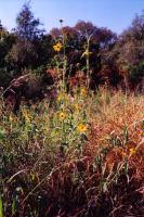
There are several meadows in the park, filled with wildflowers, tall grass and prickly pear cactus. (Photo courtesy of
kharker)
There are more trails and side paths crossing the nooks and crannies of the park landscape than you will probably ever be able to explore. There are some larger paths that can make great loops. The route described here is just one of many options. The loop and the two side out-and-back trails is about two miles in total length, with a total vertical climb of 380 feet. The trail is either natural stone, light gravel, or dirt - there are no paved sections. There are four creek crossings. Depending on how the rains have been in the previous month, the crossings are either very easy to make without getting wet at all, or will require walking through ankle-deep water. The approaches to the creek crossings can be a little steep, and occasionally muddy. Give yourself at least two hours before dusk to complete this hike.
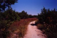
There are some large, double-track trails in the park that form a couple of big loops, popular with joggers and the less adventurous mountain bikers. (Photo courtesy of
kharker)
Begin the hike by heading due south from the parking lot. There is signage at the trail head, explaining park hours. You will quickly reach a large wide path that runs northwest-southeast, along the ridge above the Tar Branch of Walnut Creek. Take a right, heading northwest. At the waypoint "Fork1", there is a fork in the trail, and our path take the right fork. After passing through dense trees (where we lost our GPS reception briefly) the trail passes near a chain-link fence and a park maintenance "Shed", off to the right. The trail takes a left here, and crosses the Tar Branch of Walnut Creek. Just pass the creek, there is a "Fork2", our second fork, where we took a right.
After passing through some woods, the trail emerges atop a small hill with a reasonable view of the neighborhood to the northwest of the park. The land on the north side of the park is open with many meadows and grassy spaces. At "Fork3", we take a left. (Another trail goes to the right and out of the park, connecting to the adjoining neighborhood.) The trail now follows the main Walnut Creek downstream. At "Drop", there is a steep side trail that forms a little loop with the main trail. It is very popular with
mountain bikers. Follow the trail southeast until the "Side Trail" waypoint.
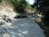
Several creeks and streams run through the park, sometimes cutting out steep rock banks.
The "Side Trail" waypoint marks an out-and-back portion of this trail. If you want to take a shorter hike, simply continue southeast on the main trail. From the "Side Trail" waypoint, take a right. This is a smaller trail that winds, at times steeply, down to the creek. At the creek, there is a flat, rocky sandbar. If you follow the sandbar all the way to the left, you can see a path on the opposite side of the creek. This is the trickiest creek crossing in the trail, so be careful.
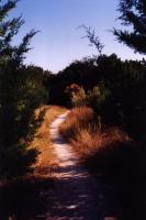
The trail, as it enters a small meadow. The evergreen trees on either side of the foreground are cedars. (Photo courtesy of
kharker)
On the opposite side of the creek, follow the trails that hug the tributary stream, which will be on your right. As you go uphill, following the GPS track, you will eventually reach "Waterfall", a small but quite pretty waterfall. You can turn back, and then head to the southeast. There is a hill overlooking the park here, and the trails going to the top can be somewhat steep. The hill is about 80 feet above the creek. Because of the steep trails, this is one of the more popular spots for mountain bikers.
The GPS track for this portion of the out-and-back includes a side trip to the southeast on a small trail that became indistinct in the leaves and ground cover. There are many side trails in the park like this that can be fun to explore. The GPS track follows a trail that heads back to the previous creek crossing "Cross1".
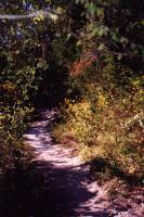
The trail goes through both open spaces and very densely overgrown spaces. (Photo courtesy of
kharker)
Once you've reached the main trail on the north side of Walnut Creek, follow the trail, taking a left to head away from the creek. This takes you through alternating woods and meadows until you approach a 4-way intersection. Take a right to continue southeast down to the creek again. "Cross2" is a creek crossing that is not as difficult as "Cross1". Once you cross the creek, take a right to continue going southeast. Near the southern boundary of the park, you will cross the creek one last time at "Cross3". The trail on the opposite shore is steep as it climbs up from the creek. Once you reach the top of the incline,
there is a fork, "Fork5", which we took to the left. This trail is one of the larger, flatter, and more heavily travelled trails in the park. if you take the trail to the right, it will follow the Wells Branch of Walnut Creek, terminating at the entrance road near the Lamar Street entrance. Our GPS track takes a left, going north and then northwest along the ridge above the
Tar Branch of Walnut Creek, and back to the parking lot.
There are any other trails and destinations in Walnut Creek Metropolitan Park. This two mile loop doesn't cross or go near the Wells Branch of Walnut Creek, which flows on the east side of the park.