Gracywoods Park

Trail
1.50 Miles
61 Feet
Free
3stars (3.36)7
1point5stars (1.64)
2stars (2.36)
N/A
Yes
Yes
No
Austin
Travis

Getting there: The trailhead starts on the sidewalk of Park Bend Drive, just south of Parmer and MoPac. From the south take the Parmer Lane exit off of MoPac and be prepared to turn right immediately onto Cedar Bend. Be very careful of cars on the service road. Take the next right along the back of North Austin Medical Center and then take the next left onto Park Bend Road. The trailhead will be on the right, just beyond the water containment basin. From the north, take the Waters Park Road exit off of MoPac and pass over Parmer Lane. Go to the next traffic light and turn left onto Park Bend Road. Park along the street next to the sidewalk that runs toward Walnut Creek.

The Hike: This hike is as easy as it gets. The entire length of the hike is paved and the distance short. It's easy enough to the point that one hesitates to call it a hike instead of a walk. But this particular outing may be ideal for an after work hike or tryout for new boots or socks.

The entire length of the trail is paved, which makes for easy going.
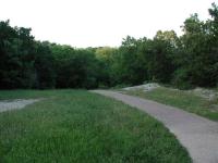
The trail starts at the waypoint "Trailhead", right along Park Bend Road. It runs along the earthen containment wall for the water runoff pond. Since the pond is usually dry it's often used for pickup ball games or folks playing fetch with their dogs. The route heads straight back towards Walnut Creek.

Upon getting closer to Walnut Creek the route veers to the left and follows Walnut Creek downstream. On the opposite bank of Walnut Creek you should be able to see a large rock cliff. Just a few years ago the scene was still quite wild. However apartment buildings now loom overhead.

The name of this trail comes from the small park that it passes through.
When you approach the waypoint marked "Metric Cross" be prepared to pass under Metric Blvd. and then walk up wooden ramps to the road level. Here you have to walk south along Metric for a short distance before the walkway into Gracywoods Park continues to the left. Note that it is possible to cross the creek without going up to Metric, but it depends entirely on the amount of rain the area has experienced. During dry periods the water level may be low enough to hop across a few rocks to the opposite bank.

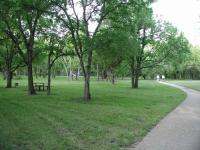
Gracywoods Park is a small recreation area that includes a volleyball court, swing set, gazebo and picnic benches. The heart of this area is marked by the waypoint "Park". Upon leaving the park the route will pass through a thick section of trees and brush. This section of the trail offers the opportunity to leave the comfort of the paved trail and explore a little.

If you venture off the main trail you can enjoy a cliff view overlooking Walnut Creek.
Walnut Creek resides to the left of the trail here, though it can not be seen due to the heavy vegetation. Several paths have been made through the area to get to the creek and it's worthwhile to try them out. If you navigate your way toward the waypoint marked "Cliff" you'll be rewarded with a wonderful rock cliff overlooking Walnut Creek. Below the cliff there is also a wide rock bank.

The trail from this point on hugs along the boundaries of apartment complexes until it reaches its end at the waypoint "Turnaround". Here you'll run into Bittern Hollow Drive. Although one could start their hike at this location we would not recommend it since parking is much less prevalent here.

As you may be able to tell from the map, the Gracywoods Park hike runs very close to the boundary of Walnut Creek Park to the east. There is probably a way to connect one of the trails from that park to this hike after crossing Walnut Creek. That's one connection we will attempt to make in the future. If you know a way through please let us know.

In all we took a little over 1 hour to complete the hike out and back. This included some time spent exploring the side trails around the cliff overlooking Walnut Creek.

Log Entries
Completing the map
By Austin Explorer on 6/1/2013
Rating: 2stars Difficulty: 1point5stars Solitude: 2stars
Distance: 1.75 Miles Duration: 35 minutes

Coppertone and I revisited Gracywoods to complete a couple of spurs that we had not mapped before.  Things looked a bit more run down than the last time we both had been here.  One of the wooden ramps leading down to the creek was boarded up  and closed since it is starting to fall apart.  We had to cross via the bridge over Metric instead.

By jtkatie on 5/23/2010
Rating: 3stars Difficulty: 1star Solitude: 2stars
Distance: 2.50 Miles Duration: N/A

Do note that you are able to cross the river by/under the bridge. After going through some thicker grass at the loop/end of the trail, there are some strategically-placed stones to help you cross. Watch out for glass and other trash under the bridge though.

Short hike
By texaskdog on 3/8/2010
Rating: 2stars Difficulty: 2stars Solitude: 2stars
Distance: 3.00 Miles Duration: 45 minutes

It was nice, but its next to the 5-star Walnut Creek Park.  Okay neighborhood hike.  The ramp to Metric is closed but you dont know that until you get to the top, but there is a low-water crossing

Still a fun walk for a toddler!
By jjuday on 5/20/2007
Rating: 4stars Difficulty: 1star Solitude: 3stars
Distance: 2.00 Miles Duration: 1 hour
There is a path along the far side of the collection pond, so we started threre istead of on the sidewalk near the apartments. Beautiful wildflowers, butterflies, lots of doves, and one handsome bird standing in the water (some sort of crane?). A lovely walk.
Great walk with a toddler - park is nice
By jjuday on 1/9/2007
Rating: 4stars Difficulty: 1star Solitude: 2stars
Distance: 1.50 Miles Duration: 1 hour
By brian724 on 5/27/2005
Rating: 4stars Difficulty: 2stars Solitude: 2stars
Distance: 1.50 Miles Duration: N/A
Very nice neighborhood park, connects to Walnut Ck
By figment on 5/15/2005
Rating: 4point5stars Difficulty: 3stars Solitude: 3point5stars
Distance: 3.00 Miles Duration: N/A
The actual path here is short, a paved trail that goes through a very nice neighborhood park with a lot of trees at Metric. I didn't cross Metric to go to Park Bend, although I could have.

When you walk this trail between Metric and Bittern Hollow, the paved trail forks at a Y. One branch goes to Metric, one goes to Bittern Hollow, and one goes to Lincolnshire (this is the shortest arm of the Y). Take the path to Lincolnshire 100ft, and you will see a trail dropping off to the left into the trees. That is the connector to the Walnut Creek park, which is much bigger and has unpaved trails. Watch out for mountain bikers on this trail. This cutoff is not very obvious, but it is the only path to the left off of the path to Linconshire.

Recommended Item
Recommended Item 60 Hikes Within 60 Miles: San Antonio and Austin: Including the Hill Country
Charlie Llewellin, Johnny Molloy
List Price: $18.95 Your price: $15.99 Buy Now
It's Time to Take a Hike in San Antonio!

The San Antonio and Austin areas are steeped in history -- San Antonio's Alamo stands as a symbol of Texas' fierce independence, while Austin is recognized as the cradle of Texas statehood. This area is also known for some of the most impressive hiking in the Lone Star State. 60 Hikes Within 60 Miles: San Antonio and Austin, by veteran authors Charlie Llewellin and Johnny Molloy, guides readers to the best trails found in the Texas Hill Country, all within easy reach of these two cities. The guide takes you to secluded, low traffic areas as well as those that are more popular and heavily used. The former LBJ Ranch, the Guadalupe River, the Highland Lakes Chain, and the Lost Pines area are just some of the spectacular places covered.

With this new edition in the best-selling 60 Hikes Within 60 Miles series, all these visually stunning and ruggedly charming routes are at the traveler's fingertips. This handy guide helps San Antonio and Austin natives get back into nature, with many options right in town. Extensive at-a-glance information makes it easy to choose the perfect hike based on length, difficulty, scenery, or on a specific factor such as hikes good for families, runners, or birding. Each trail profile includes maps, directions, driving times, nearby attractions, and other pertinent details.