Getting there: From Highway 183 in northwest Austin, take the Spicewood Springs exit and head south on Spicewood Springs Road. Continue on the road as it turns into Old Lampasas Trail. Turn right onto Talleyran Drive and head north. Look for the park on the right after travelling several blocks.
The Hike: Talleyran Park is a great little neighborhood park featuring a nice, short trail in addition to the typical playscape and baseball field. To the City of Austin it's known as the Northwest Balcones Park and much of the trail resides in the adjacent Upper Bull Creek Greenbelt. The trail begins just behind the baseball field at the waypoint marked "Trailhead". A sign here indicates that the Northwest Travis MUD #1 sponsored the effort
to build the trail, which was spearheaded by Ryan Odom as an Eagle Scout project.
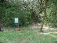
The trailhead resides near a baseball diamond in the park.
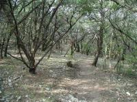
The trail quickly enters a flat, but rocky stand of Juniper. In a short distance the level path makes a rapid descent towards the creek that runs through the park. Near the waypoint "Rock" the trail passes near a large rock face that is exfoliating large boulders that break free, slide downhill in geologic time and break up into smaller boulders in the process. The difficulty rating for this hike would be far higher if most of the trail terrain was like this.
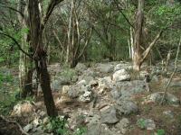
The trail gets quite rocky as it descends from the trailhead to the creek bank.
Up to this point red arrow trail blazes marked the direction of the trail. As the rocky slope becomes more gentle the trail blazes should not be followed. There appears to be an effort to change the path of the trail. Look for bright yellow and orange surveying tape tied around branches that mark where the new trail segment will be. The trail blazes say to go right, follow the tape to the left.
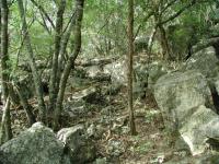
Did I mention that it was rocky here?
The new trail segment looks like it will be an improvement over the old route. But both end up at the same spot at the bottomlands of the creek floodplain. Here the trail flattens out and becomes less rocky. Occassionally the sky opens up over the trail, but tree cover is the norm for much of the hike.
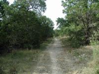
Once along the creek bed the trail flattens out and even opens up a bit in places.
You'll spot a rock border which highlights a creek crossing on the left. Keep heading south on the main trail and we'll get back to this point later. The trail continues south until it runs into Old Spicewood Springs Road, marked on the map by the waypoint "Trailhead". Both the St. Edwards Park and Upper Bull Creek trails are tantalizingly close to this spot and one is tempted to try and connect two of them to create a longer hike. It's not certain that the direct routes
would entirely traverse public property however.
Despite some openings, much of the trail enjoys heavy tree cover.
A disturbing sight near the turnaround point is the back fence of a miscreant who appears to be tossing over trash and debris out of his yard and into the park. His out of sight, out of mind attitude is disturbing to say the least. Outside of this one aberration the park is mostly devoid of trash.
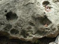
A careful examination of rocks uncovered several fossils of sea creatures that used to live here.
Backtracking from the turnaround point a far more elaborate creek crossing can be found to the right. There is a large mass of rocks piled up and stacked to create a set of stairs that descends to the creek bed and back up the bank on the
opposite side.
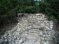
This well built rock staircase makes crossing the creek easier.
From here the trail turns to the north and parallels the trail on the opposite side of the creek. The east bank is more evenly wooded and a large number of doves seemed to find the area to their liking. One dove appeared to have nested quite near the trail. Despite never seeing where the nest was the maternal dove shook and quivered on the ground, pretending to be injured so as to lure me away from her young. As I continued to hike along the trail she would fly forward, land, glance back to make sure that I was still following and recommencing her dance. I stopped at one point and just waited to see what she would do after flying around a corner of trees. In a short period of time she doubled back, peeking around the corner and enticing me further.
The trail returns to the original creek crossing that I passed up on the initial leg of the hike. The crossing here is not as elaborate as the one at the southern end of the trail, but it presents no problems for crossing, particularly given that the creek was dry during our visit. From here I backtracked to the trailhead, passing through the boulder
field one more time.