Getting there: From Austin head east on Highway 71. Take the Loop 150
exit and continue east to the intersection with Highway 21. The entrance to the park is in the middle of the Y-split in the road. Once in the park turn left at the T-section in the road past the ranger station. Continue on State Park Road 1A until it intersects with
State Park Road 1C. Turn right to continue on Road 1A and look for the parking area on the right soon afterward.
The Hike: The Lost Pines Hiking trail is an enjoyable stroll through a forested area resembling East Texas, right here in the Hillcountry. The hike starts at the waypoint "Trailhead" which is right across the street from the parking area. From here the path descends into the small valley of a creek. The forest is thickest at these lower elevations due to the increased moisture from the creek.
-small.jpg)
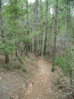
Yes, there's a trail here. If you have trouble seeing it look for the trail blazes on the trees.
On the opposite side of the creek the trail rises to the waypoint "Overlook Junction". Here the trail splits into two. Either direction will work, but on our trip an oncoming group from the left sent us to the right in search of a quieter walk. Generally speaking, the closer to the trailhead you hike the more people you'll encounter. There is ample solitude on the back end of this hike.
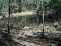
The numerous ponds that dot the landscape are favorite Houston Toad breeding grounds.
The trail heads south crossing the creek that's creating this valley in the process. At no time during our hike did any stream present a barrier. Typically traversal was over a dry creek bed or picking a dry spot between puddles of standing water.
At waypoint "Pond 1" the trail comes upon a pond, the first of many along this trail. These small, tranquil ponds are ideal habitat for the endangered Houston Toad. The Toad can be found in only 9 counties in Texas and is found nowhere else on Earth. Bastrop State Park has the largest known concentration of toads and thus is vital for the species' survival. Texas Parks and Wildlife recently purchased an additional tract of land to the north of the park for additional Houston Toad Habitat. At this time it's not certain when or if that additional land will be included in Bastrop State Park or set aside as a wildlife preserve.
Most of the trail consists of east terrain, though a few spots are mildly steep.
Trailhead Junction, like Overlook Junction, splits the trail. To the right there's a scouting camp area and a quicker access to State Road 1A. We turn left and head east, away from the more crowded areas of the park. Note nearby the rock outcropping - it's the only one that you'll see on the hike. Most of the hike will consist of rolling hills with thick layers of loomy soil. There's also an
orienteering flag here, to give you an idea of what orienteering adherents look for in the park.
The trail crosses a jeep path at the waypoint "Road Cross 1". From this point eastward hikers may set up camp anywhere along the trail, provided that suitable setbacks from the trail itself and water sources are maintained. Later in the hike the trail also crosses what is marked as County Road 180. However, this dirt road is scarcely larger than the first dirt trail and we never saw any vehicle on any of them. Despite this, one should always proceed with caution at such crossings.
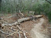
Dead trees, or snags, are not an eyesore. They're a natural part of a forest's cycle of rebirth.
The official park map does not indicate the crossing at the waypoint "Power Lines". Here large, high-tension power lines cut through the park north-south. To keep trees from tangling with the lines or restricting the power companies ability to service the line all trees under the towers have been removed, so there's a large swathe of grass running through the forest.
Soon after re-entering the forest we came upon one of our favorite portions of the hike. A glade of large pine trees here keeps the floor brush to a minimum and the tree spacing is a bit larger than elsewhere. One almost gets the feeling of being in an old growth forest. Since we're just about as far away from the trailhead as this trail will lead us, this quiet spot was a ideal place to stop for a rest and a snack.
The farther away from the trailhead you travel the fewer people you'll encounter. This backpacker and his dog were one of the few.
As the trail turns to the north in preparation for the homestretch the path plays a game of tag with the creek that runs here. For the next mile or so the trail will cross the creek no less than 10 times starting at the waypoint "Creek Crossings".
The route back includes some climbing to make up for all of the downhill we enjoyed on the way out, however, it's very tame by Hillcountry standards. And when at the top of the ridge overlooking the creek valley below one is afforded some great views of the forest below.
We head back to the start by continuing west and then retracing our footsteps down and up the creek valley when we get back to Overlook Junction. Overall, this is a great hike and one highly recommended. While the official park map indicates that this hike should be about 8 miles (less the .6 mile spur from Trailhead Junction to State Park Road 1A) we found the distance to be more in the area of 7 miles using our GPS. We'll take along the GPS on a future trip and see whether or not we get different results.