Pedernales Falls - Wolf Mountain Trail

Trail (3.62)
(2.85) (3.65)
8.25 Miles 650 Feet
N/A No
Yes Yes
$4.00 More Info
Johnston City Blanco
Loading...
Larger Map

The Wolf Mountain Trail in Pedernales State Park is one of the more complete hiking experiences in the central Texas area. (Click on map for larger view) (Click on map for larger view)
Maptech® USGS Topographic Series™, ©Maptech®, Inc. 603-433-8500, www.maptech.com/topo Copyright 2000 Maptech, Inc.

Getting there: From Austin head west on Highway 290. After near 30 miles turn north on RM 3232. Continue north until 3232 dead ends into a T-section in the road. The entrance to Pedernales Falls State Park is to the right off of FM 2766. Upon entering the park continue driving approximately 3 miles to the turn into the parking area for primitive camping that also refers to the Wolf Mountain Trail. We recommend getting there early on nice days as the parking area can fill up quickly.

The Hike: The Wolf Mountain Trail is one of the Hillcountry classics. The hike provides a wide variety of sites and experiences that includes scrub land, dense Cedar woodlands, valley vistas, springs and history all in one.

A good portion of the Wolf Mountain Trail is an old jeep trail.
The trail starts at the waypoint "Trailhead" initially heading south, but soon meandering as it hugs the contour of the hills. The trail surface at the beginning is a rocky jeep trail, but not too rough. At the waypoint "Creek Cross" the trail crosses it's first body of water. Like the others, this one will not provide much of an obstacle except on days immediately after a heavy rain.

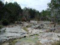
There are several creek crossings on the hike, but none of them will provide much of an obstacle.
As the trail approaches the waypoint "Bee Creek" look to the left for views of the small, but steep canyon walls that line the creek. There are a couple of spurs along the trail that head to the canyon edge for a better view.

Upon reaching the waypoint "Mescal Creek" be careful to avoid the the trails headed into the primitive camping area if you are intent on continuing the hike. A large sign marks the start of the camping area just beyond Mescal Creek. A short distance away the trail splits. Take the right fork to stay on the trail and a while later take the left fork at the "Y-Left" waypoint. This marks the spot at which we'll complete the outlying loop.

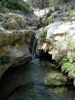
Jones Spring is near the halfway point of the hike and is a pleasant place to take a rest.
As the trail continues to head east you might see campers to the left. The area is popular with individuals and scouting groups as I saw several on the trail and in the camp area. Some folks seem better prepared for primitive camping that others. One group of folks I encountered on the trail were making a racket of noise by pulling a wheeled ice chest behind them to go along with the rest of their camping supplies. Had the idea been feasible I imagine they would have lugged an air conditioner along with them! Primitive restroom facilities are available at the end of the camping area at the waypoint "Restroom".

One of the highlights of the hike and a perfect place for a rest is at the waypoint "Jones Spring". Here a small spring feeds a constant ripple of water down a small canyon lined with fern. The sound of trickling water and the wind through the trees is soothing and there are ample rock surfaces on which to recline. Please be careful to avoid trampling on the vegetation around the spring as it is quite delicate.

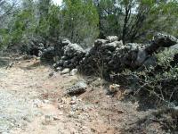
Pedernales Falls used to be home for ranchers and farmers. Stone walls and the ruins of house can be seen from the trail.
After a rest and a snack next to Jones Spring I headed back onto the trail and soon found the ruins of a settler's house. Folks who have found artifacts on the ground have placed them on the remains of the house's walls. Although none of them are likely to be archaeologically important or for that matter very old, the rusty and weathered pieces echo some of the activities that took place here in the past. No artifacts should ever be removed from a state park.

The trail heads southwest. As it does so it ascends a creek valley's slope. The foliage cover becomes thicker and provides a welcome relief from the Sun. Eventually the trail once again follows the contours of the hills, thus saving the hiker from too much climbing and descending. Had the layout of the hike consisted of more straight lines the difficulty rating of this outing would have been much higher.

At the waypoint "Y-Right" the trail runs into a jeep trail. Turn right at this point to head to Wolf Mountain. The trail to the left proceeds in almost a straight line to the county road near the edge of the park boundary.

On the back end of the trail the path is less crowded, slightly more narrower and a bit more shady.
The trail system completely encircles Wolf Mountain and I intended to sample both sides of the mountain. At the waypoint "T-Right" I choose the Pedernales River side as the first half and consequentially the side that would be visited twice. It's definately the better choice as some of the overlooks to the Pedernales River valley below are stunning. The waypoint "Overlook" marks a point in particular that held my attention for some time.

The "Y-Left" waypoint provides an option for the hiker who is ready to cut the day short. By proceeding to the left one is rewarded with views of the wooded valleys and canyons of Mescal Creek. The trail will loop around back to the "T-Right" waypoint that started the loop around Wolf Mountain and the hiker is presented with an option of doubling up the east or west trails around the peak. Wanting to see the Pedernales River again I choose the east side.

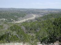
The trail around Wolf Mountain looks down upon the Pedernales River valley below.
The second visit to the "Y-Left" waypoint is an indication to go right and start the journey back to the trailhead. The trail descends along a rocky and occassionally steep incline before joining up with the original trail near the primitive camping area. Turn left at that point and follow your footsteps back to the trailhead.

Wolf Mountain is one of the most popular long hikes in the Central Texas area. Like many hikes, the farther from the trailhead one goes the fewer people one encounters. However, this only works so much and at Wolf Mountain it was never enough to truly be alone with the exception of the creek valley beyond Jones Spring. Nevertheless, the four hours on the trail was time well spent.


As soon as we began the trail, I ventured off and found this cute little stream of water. (Photo by AshleyNicole)

(Photo by AshleyNicole)
House Ruins - Pedernales Falls - Wolf Mountain Trail

(Photo by jmitchell)
Pedernales Falls - Wolf Mountain Trail

(Photo by jmitchell)
Pedernales Falls - Wolf Mountain Trail

(Photo by jmitchell)
Pedernales Falls - Wolf Mountain Trail

(Photo by jmitchell)
Pedernales Falls - Wolf Mountain Trail

(Photo by jmitchell)
Pedernales River

View looking east on the Pedernales River, just north of the bluffs. (Photo by omgjoz)
Trammel Crossing

This is near the beginning of the trail. Cross the river and start going up. (Photo by tjbustem)

Logs

Have you visited this location? What did you think of it? Submit your own log entry to let others know of your experiences and to keep track of your adventures.

User: dgray216 - 10/11/2009  [View Log Page]
Rating: Difficulty: Solitude:
Distance: 2.00 Miles Duration: N/A
Hilly, Scenic, Peacefull
User: tjbustem - 2/21/2009  [View Log Page]
Rating: Difficulty: Solitude:
Distance: 5.00 Miles Duration: 2 hours, 30 minutes

Rugged enough to keep the causal hiker away.  Saw wildlife and lots of wild flowers.  There's an old cemetery at the top of the trail that's very interesting.  If you don't look for it you will miss it.

User: johnbivona - 2/1/2009  [View Log Page]
Rating: Difficulty: Solitude:
Distance: 8.25 Miles Duration: 5 hours, 30 minutes

Most of this hike is on an improved trail, gravel road, used to access the primitive camp site.  The ruins at Jones Spring is a nice stopping point for lunch.  Check out the stone fence next to the ruins; hand built & most have taken forever!  After the ruins, the trail narrows and is a little more difficult to follow.

Nice hike on a beautiful day.
User: BANDA - 1/31/2009  [View Log Page]
Rating: Difficulty: Solitude:
Distance: 7.30 Miles Duration: 4 hours, 30 minutes

We enjoyed this hike today on a beautiful day. There are some really scenic ravines near the trail that can be seen if you take some of the small side trails. We have hiked this trail before, and have only seen other hikers in the past, but today a ranger in a pickup passed us going out as we were going in, then one passed us on foot  and another passed in another pickup going in as we were going out. Not sure what was going on but this seemed like a lot of ranger traffic and a lot of vehice traffic on the trail. Other than that it was pretty quite exept for several other groups of hikers and backpackers that we passed. There are some nice primitive camp sites in the area.

User: swatmama67 - 11/7/2008  [View Log Page]
Rating: Difficulty: Solitude:
Distance: 7.50 Miles Duration: 4 hours, 30 minutes

My husband and I took the Wolf Mountain Trail on a Friday morning.  We only saw one other couple until we were leaving, when we met a youth group hiking in with camping gear.  I was somewhat disappointed with this trail.  As someone else mentioned, most of the trail is actually like a road.  Turns out walking on crushed gravel is harder on the feet and legs than we thought.  Ouch.  

We took the jaunt up to Jones Spring which was interesting- it was neat to see the ruins of the structure, but we wished there had been a marker with some kind of info.  We stopped on Wolf Mountain for lunch.  It was extremely quiet.

It had not rained in quite some time so all of the creeks and even the spring were mostly dry.

We did see a small snake trying to eat a much larger frog- that made a terribly disturbing sound.  And, off the trail but still noteworthy- we saw another snake sunbathing on the rocks where you can walk out onto the rocks in the river.

I think we will try this train again in the spring after there has been some rain.

User: nurse4rocks - 8/16/2008  [View Log Page]
Rating: Difficulty: Solitude:
Distance: 10.30 Miles Duration: 3 hours, 23 minutes
Perdanales
User: Weilo - 7/7/2008  [View Log Page]
Rating: Difficulty: Solitude:
Distance: 4.50 Miles Duration: 2 hours, 30 minutes

We went up with the Boy Scouts and took the  younger ones on the 4 mile loop and ended up coverin about 4.5 miles. Had a good time.

Great Hike
User: bspross - 7/4/2008  [View Log Page]
Rating: Difficulty: Solitude:
Distance: 8.25 Miles Duration: 3 hours, 5 minutes

This is a great hike close to Austin.  It was very dry and none of the creeks had any water; however, the views are spectacular.  One note, if you are camping in the primitive area, don't take a wagon full of supplies.  There is a very steep uphill getting to the primitive hiking.

Everything about this trail is nice.  We went on the 4th of July and there was no one out there.  We did not pass anyone on the way out and only passed 7 people going to primitive hiking on the way back.  7 people over 8.25 miles is great for the solitude.

Make sure you stop at Jones Springs and check it out.  There wasn't much water in it either, but we had a little snack on the rocks.  There is a big sign so you won't miss it.

Not much for animals on this one.  All we saw were lizards, but they were fast little suckers.

All in all a great hike and highly recommended!

Good day hike/over night
User: omgjoz - 5/29/2008  [View Log Page]
Rating: Difficulty: Solitude:
Distance: 18.00 Miles Duration: 1 day

I hiked the majority of the trails in one day.  The campsites are nice.  Only saw a couple people.  Besure to get a site on the bluffs just above the river, not above the creek :)  There are a couple rock walls good for climbing on the north side of the bluffs.  When I went in mid-may, it was very hot! So be prepared.

Hike through the hill country...
User: lordvallsbyrd - 5/21/2007  [View Log Page]
Rating: Difficulty: Solitude:
Distance: 8.00 Miles Duration: 3 hours, 30 minutes
The first two to three miles of the hike up to the primitive camping area was fairly uneventful following a jeep trail all the way. There were some nice camping spots on the bluffs however and the rest of the hike was pretty rewarding. Jones Spring was nice and the old historical structure was interesting. The backside of the trail was by far the most enjoyable as you enter a patch of woodlands and then hike along the side of wolf mountain with some nice views. Overall I would say that it was an excellent hike that makes you work for its real beauty.
Fantastic hike
User: WalkerTexasHiker - 10/27/2006  [View Log Page]
Rating: Difficulty: Solitude:
Distance: 7.50 Miles Duration: N/A
My wife and I did this one just last week...our first real hike since we took up this hobby and my first real hike in probably 25 years. We enjoyed it greatly and the views are well worth the effort, especially around the 5 mile point where you look out over the valley below. More seasoned hikers probably will scoff at my suggestion that the trail is rather rugged and difficult in some places and when we chose to take the branch of the trail over towards the primitive camping area, the trail deteriorates into several footpaths and it makes finding your way out a little less clear than I like. That said, we had no problems. Be aware though that the little map they give you at the ranger HQ isnt really adequate for hiking extended distances here and a couple of times we found the trail and the map to be in totally opposite agreement. It would probably be best to use GPS for this if you are at all unsure. The remains of the old stone house were interesting as was the extensive remains of the rock wall. I was really pleased to see that previous visitors didnt pocket the artifacts they came across and instead, piled them up on the walls of the house so that others could see them. While we were there, we added to it by finding several iron nails, colored glass and some fragments of china. We are definately going back to do this one again.
It's Hot Out There!
User: kcameron - 7/23/2006  [View Log Page]
Rating: Difficulty: Solitude:
Distance: 7.50 Miles Duration: N/A
Although we were on the trail by 8:30 AM, by the time we finished the hike the heat was pretty oppressive. Because much of the trail is actually a road rather than a footpath, there is not a lot of shade. We did enjoy the part of the trail just east of Wolf Mountain where the foot path leaves the road and ventures off to Jones Spring. Coming upon the numerous rock walls and the ruins of the old house was interesting. We encountered 7 people on the trail, and we heard numerous others along the river.
Interesting areas
User: Riff Raff - 5/20/2006  [View Log Page]
Rating: Difficulty: Solitude:
Distance: 7.50 Miles Duration: N/A
Very nice trail. As mentioned previously, you'll see significantly more people on the section between the trailhead and the primitive campground. It seems like a very popular backpacking destination for boy scouts and other youth groups. The trail is easy for the most part, and extremely well marked. There are mile markers every half mile, without fail, through the entire trail. The springs area was a nice place to stop, take a break, and eat lunch. My only complaint was that most of the trail doubles as a gravel road, so it's very sunny and wide. My favorite part of the trail was definitely the section between the springs and Wolf Mountain itself, which was actually a trail and NOT a gravel road. And the section going around Wolf Mountain just had outstanding views all along it. Very enjoyable, all in all.
It is what you make of it
User: Soonhorn - 11/5/2005  [View Log Page]
Rating: Difficulty: Solitude:
Distance: 8.00 Miles Duration: N/A
Very easy long hike with lots of crushed stone. You will feel it by the end. Here is the secret...Go to the primative camping area and then follow the little trail along the cliff, it will eventually hook back up with the main trail. While in the primative camping area, snoop on down to the river and goof around down there. At the loop park of the trail they need to cut some cedar trees down to open up what would be super views. Maybe a bench along that area would be nice.
Great peaceful hike, lots of things to see
User: jmitchell - 7/24/2005  [View Log Page]
Rating: Difficulty: Solitude:
Distance: 8.00 Miles Duration: N/A
Not very difficult
Too many people
User: enhance - 5/1/2005  [View Log Page]
Rating: Difficulty: Solitude:
Distance: 8.50 Miles Duration: N/A
The trails are big enough to drive a truck down. People were everywhere. Lots of people were "camping" in the area provided, but while surrounded by other campers. This is a good hike if you're really old or don't walk much. However, parts of it were pretty cool. Some of the waterfalls were beautiful and if you get off the trail a bit it isn't too bad. It's not a great hike if you're really looking to get away from civilization though. This is a perfect hike for people who might be afraid of getting eaten by bears or killed by raccoons, you'll feel really safe and get to see trees.
User: AshleyNicole - 4/16/2005  [View Log Page]
Rating: Difficulty: Solitude:
Distance: 8.00 Miles Duration: N/A
At the beginning there were lots of people, but the further in you went the less people there were. Good hike!
Nice long hike
User: ruskinmi - 2/20/2005  [View Log Page]
Rating: Difficulty: Solitude:
Distance: 8.50 Miles Duration: N/A
This is a nice, long hike with lots of little creeks along the way.
great overnight primitive camping
User: granolo - 1/8/2005  [View Log Page]
Rating: N/A Difficulty: Solitude:
Distance: 8.50 Miles Duration: N/A
Primitive camping area was beautiful, and descending the bluffs to the river offers great riverbank wildlife spotting. Over two days I counted 17+ wild hogs in two different groups on the opposite riverbank. They ranged in size from large males to many small babies (maybe a few months old). Also saw deer, a blue heron, woodpeckers, countless cardinals, and 3 juvenile vultures (black) in a tree at the edge of my camp. They let me get very close to the tree they were in, and they were only about 20' up. The tree was on the edge of the bluffs, so i got a few semi-good pictures of them, including 2 of them when they finally did fly away. My third hike/first camping here. The low solitude rating is due to the fact that all evening into the night I was able to hear, sometimes very clearly, a live concert taking place somewhere near. The band was pretty good, though...
a very good workout
User: theatrewizard - 6/29/2003  [View Log Page]
Rating: N/A Difficulty: Solitude:
Distance: 7.50 Miles Duration: N/A
not having hiked in quite a while, we had our work cut out for us.
Very nice hike; quiet
User: texasgrape - 5/30/2003  [View Log Page]
Rating: Difficulty: Solitude:
Distance: 7.50 Miles Duration: N/A
Temp went over 100 both days! Hiked the entire trail and camped in the primitive area that nite. Saw no one all day or all nite. The only thing I saw on Friday nite was the biggest raccoon I've ever seen. We heard its 'woman's like scream' thrice during the nite. Very eerie. Also, it took all our food that was hanging from a tree on a rope. Smart coon; dumb human. Jones Spring is awesome. Had we found the way to the river from the camping area, it would have been much better. In Parent's book "The Hiker's Guide, he says, "scramble down to the river to cool off." Man we needed that river; never did find the way down to it. Take plenty of water in the summer. Nice views; nice hike. :-)
Fun hike
User: inaustin - 4/16/2003  [View Log Page]
Rating: N/A Difficulty: Solitude:
Distance: 7.50 Miles Duration: N/A
Take plenty of water and a snack for a stop at Jones Spring. Start 4 hours before dark! Beware the daddy longleg season in the spring or be ready for a shocking surprise if you use the primitive site latrine! If there is enough daylight, take a quick dip on the river through the regular campsite area to cool off (lots of nice restrooms for those inclined). I still believe it has the longest 1/2 mile marker I've walked.
My first Hike (OUCH)
User: adonaione - 12/29/2002  [View Log Page]
Rating: N/A Difficulty: Solitude:
Distance: 7.00 Miles Duration: N/A
Haven't hiked in decades, so I decided to bite off a 7 miler with my two (sled) dogs!
I hiked only part of it
User: maxrebo - 11/22/2002  [View Log Page]
Rating: N/A Difficulty: Solitude:
Distance: 4.00 Miles Duration: N/A
Did not find this wonderful trail until almost time to leave. Will hike it soon
Deceptive Hike
User: JClair - 4/10/2002  [View Log Page]
Rating: N/A Difficulty: Solitude:
Distance: 8.50 Miles Duration: N/A
In short, it's more difficult and longer ( time wise )than you think....but is a GREAT hike. After you get pass the primitive camp sites ( about the first 2 miles ) it was just me and a coyote, that ran across the trail about 300 ft. in front of me, the rest of the way. The solitude is grand, start early ( I did not )and you will not run into daylight problems and you will enjoy the hike all the more. Try it!
A spectacular day
User: Austin Explorer - 3/16/2002  [View Log Page]
Rating: Difficulty: Solitude:
Distance: 8.25 Miles Duration: N/A
Despite a forcast of dreary skies this hike provided some nice sunshine. The backside of this hike is the best, but on the whole its a great mix of hillcountry views, dense forest and open scrubland.
Loved this park.
User: Eveline - 3/2/1996  [View Log Page]
Rating: Difficulty: Solitude:
Distance: 8.00 Miles Duration: N/A

Recommended Item

Recommended Item Official Guide to Texas State Parks (Learn About Texas)
by Laurence Parent
List Price: $21.95 Our price: $13.94 Buy Now
Whether you enjoy looking at scenic landscapes, touring historical sites, camping, fishing, hiking, backpacking, swimming, boating, horseback riding, rock climbing, or almost any other outdoor recreation, there's a state park in Texas where you can pursue your pleasure. From the Panhandle to the Rio Grande Valley, the Pineywoods to the Big Bend, some 125 state parks offer you a natural escape from fast-lane living. This book is the only official and complete guide to the state parks of Texas. Loaded with accurate, up-to-date information from the Texas Parks and Wildlife Department, it describes the attractions of each park and gives details--including a locator map--about camping and lodging facilities, types of recreation offered, and addresses and phone numbers for more information. To assist you in planning trips, the parks are grouped into seven geographic regions--Big Bend Country, Gulf Coast, Hill Country, Panhandle Plains, Pineywoods, Prairies and Lakes, and the South Texas Plains. With gorgeous color photographs and an inviting text, Laurence Parent depicts the natural features and attractions of each region. So if you want to watch the sunset over Enchanted Rock, fish in the surf on the beach at Galveston, or listen for a ghostly bugle among the ruins of Fort Lancaster, let this book be your complete guide. Don't take a trip in Texas without it.