Getting there: Head west into Fredericksburg on Highway 290. In the
middle of town turn right onto RR 965 and head north. After traveling approximately 18
miles look for the entrance to Enchanted Rock State Natural Area on the left.
Upon entering the park drive to the southernmost point of the parking area to get to
one of the trailheads.
The Loop Trail meanders around the peaks at Enchanted Rock, but there are ample opportunities for scrambling around rocks along the trail.
Though the Loop Trail is the longest trail in the park, it is also probably the easiest trail at Enchanted Rock, terrain wise. To complete the loop you'll log 4 miles, but the path is largely flat and typically easy to navigate, with a few exceptions.
Our hike began at the waypoint marked "Trailhead" located near the southernmost parking
area in the park. The trail here, as through most of the hike, consists of crushed granite and is quite wide. Part of the trail follows old jeep trails from the land's ranching days and the wider stretches of the trail are occasionally patrolled by rangers in a truck.
-small.jpg)
A view along the trail. At the two large boulders a side trail leads to an overlook to the north.
As the trail heads west it runs along the flood plain of the Sandy Creek.
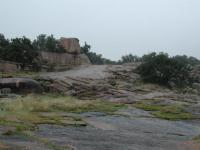
The park's rocky nature really makes itself apparent as the trail turns to the north.
Unlike most of the rock one sees in the Hill Country, this rock is pink. Enchanted Rock
and most of the formations here are made up of granite. The rock erodes more slowly than limestone and as it does it tends to wear more smoothly. At the first rock outcropping of the trail we had to step carefully to maintain traction on the rock due to mist that permeated the air and coated the rock, making for slippery surfaces.
Many of the rocks found along the trail resemble mushrooms, with wide tops. The shape of these rocks is due to the pattern of erosion, typically freeze-thaw weathering. At the waypoint "Window" one can see a different result of erosion. A rock here has a hole bored straight through it.
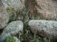
In the micro climate at the base of many rocks here moisture loving plants such as these ferns find an oasis in which to grow.
There are a couple of side trails encountered on the hike, many of which are not official. One official trail veers off of the mail loop opposite two huge boulders. The short spur heads north to the waypoint "Overlook", which normally provides a panoramic view of the area. Due to the overcast day of our visit there was not much to see, however.
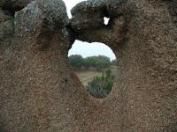
Erosion on this rock has taken a bit of a twist. A window has formed through it.
Being a State Natural Area, one might expect to see lots of animals at Enchanted Rock.
Indeed there are a lot present. On the trail we observed a large number of birds,
including Robins, Doves, Tit Mice, Woodpeckers and several varieties of Sparrows. We
wished we had brought our binoculars to get a better look at some of the flocks. The
open nature of the vegetation means the birds typically keep a wide berth of people.
Near Moss Lake, at the intersection with the Echo Canyon Trail (marked with the waypoint
"Y-L") we continued to the left to complete the main loop. If you want to cut the hike
short turn right here to take a more direct route back to the park headquarters.
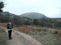
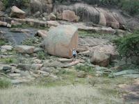
Coppertone on the Loop Trail with Enchanted Rock in the background. This photo shows both the exfoliation of Enchanted Rock and a little part of the quartz explosion at Coppertone's feet.
The trail section between Moss Lake and the turn toward Freshman Mountain is actually not too terribly interesting, compared to some of the rock formations encountered thus far and soon to be encountered. Why bother coming this way? Why not just turn down Echo Canyon, where the terrain is more varied and entertaining? Because you never know what you'll find around the bend.
With Freshman Mountain and Buzzard's Roost rising before us we saw what from a distance
appeared to be trash on the trail. What resembled shredded newspaper from afar was actually an explosion of quartz. From a little mound above the trail, a vein of quartz had weathered away and broken into pieces that littered the path with nuggets of all sizes and scattered them downhill and into a creek bed.
Austin Explorer next to some of the large boulders that have exfoliated from Buzzard's Roost.
Still excited from the quartz explosion, we followed the trail as it bisected Buzzard's
Roost and Freshman Mountain. To the right, Freshman Mountain presented some sheer rock
walls that a few rock climbers challenged. To the left, the more gentle slope of Buzzard's Roost deposited huge boulders at the base of the hill, perfect for rock climbing of a more tame sort. We spotted a fox squirrel near a running stream here. Though not tame, he did not seem too disturbed by our close proximity. All things considered, this may be our favorite spot along the hike.
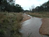
The Loop Trail running along the banks of Big Sandy Creek.
The trail crosses Sandy Creek at the waypoint "Creek Crossing". Due to recent heavy
rains the crossing was harder than normal, though still not too difficult. Once on the
opposite side of the creek the trail heads south and follows the creek's edge. For the
first time on the hike the trail surface here includes some packed dirt.
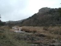
Big Sandy Creek running past Turkey Peak on the right.
After passing the group shelter at the waypoint with the same name we happened upon a
White Tailed Deer crossing the creek to put some distance between herself and us. Only after watching the deer disappear over a ridge did we turn around and notice three more deer, just a short distance behind us. Once they saw our attention focused on them they also vacated the area.
The Loop Trail officially crosses the creek again before intersecting with the Summit
Trail and running into the northernmost parking area in the park. We missed that crossing though, perhaps due in large part to the higher waters in the creek. Instead, we continued to follow a marked trail on the eastern side of the creek until it ran into the opposite side of the long the parking lot from our trailhead. Not counting the traverse across the parking lot at the end of the day we covered 4.5 miles in a slightly modified loop around the mountains.