[ Log In ] or [ Register ]
Austin Explorer

Enchanted Rock - Summit Trail

Trail (4.10)
(3.11) (1.74)
0.75 Mile 800 Feet
N/A
Yes No
$6.00 More Info
Fredericksburg Llano
Take Action Bookmark and Share

Getting there: Head west into Fredericksburg on Highway 290. In the middle of town turn right onto RR 965 and head north. After travelling approximately 18 miles look for the entrance to Enchanted Rock State Natural Area on the left. Upon entering the park drive to the northernmost point of the parking area to get to one of the trailheads.

The Hikes: The path to the summit of Enchanted Rock is the most popular trail in Enchanted Rock State Natural Area and one of the more well known hikes in the state. The trail starts at the waypoint "Trailhead" on the topo map, near the turnaround at the northernmost parking area, and heads north. A restroom and water fountains are available nearby. Concrete steps make crossing Sandy Creek easy as the path leads up to the base of Enchanted Rock. On the large topo map Summit Trail is marked in red and other trails at Enchanted Rock are shown in blue.

Enchanted Rock is a known as a batholith - a large rounded dome of granite that formed as a pocket of magma under the surface of the Earth. Estimates place the occurance of this formation at up to 1 billion years ago and the rock here is some of the oldest to be found in North America. Over time the surrounding limestone, a type of rock that more quickly erodes, began to weather away until the granite formation has finally begun to appear above the surface. Enchanted Rock is the second largest granite batholith in the United States, behind only Stone Mountain in Georgia.

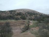
Enchanted Rock, as seen from the observation platform near the Summit Trail trailhead.
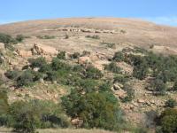
As the path begins to ascend the rock it picks its way around a boulder field. The rocks here started life farther up the mountain. In a process of exfoliation these layers of rock that used to form the surface of the dome broke apart and slid down the new smooth underlying layer of rock and ended up here. Keep an eye open for trail markers uphill as sometimes it is difficult to differentiate the official path from other routes.

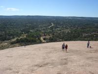
Hikers work their way toward the summit.
Near the waypoint "007" on the larger topo map, which is the intersection of the Echo Canyon Trail with the Summit Trail the boulder fields begin to thin out and the smooth surface of the dome begins to predominate. Large boulders that have "calved" off of the dome are still to be found on the slopes, seemingly still but actually moving in geological time downhill.

Looking down the trail from near the top. The rock looks barren here, but that's not the case elsewhere.
The trail on the dome is occasionally steep and can be slippery when wet. It also makes for a great stairmaster workout replacement. Once you've reached the smooth dome surface trail signs become moot. Just head uphill in whichever direction you prefer. A short ridge of rock provides the only obstacle. Just pick which way you'd rather go around it.

Near the summit you'll see more and more shallow depressions in the granite. These formations are called vernal pools. The larger ones may still contain standing water well after a rain. More interesting are the pools that over time accumulate plant debris and soil. Eventually a small plant community will take hold on a permanent basis, providing a small oasis of life on the the face of solid rock. One of the larger communities near the summit even supports a small tree.

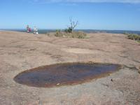
Depressions in the rock eventually host vernal pools (foreground), that eventually turn into small pockets of vegetation (background).
The summit is not a peak, but merely the highest point of the dome of rock. From the top the mountain slopes off gently in all directions, offering 360 degree views of the surrounding terrain. The winds can be gusty at the top and it certainly was when I visited. Even with a chin strap I ended up stowing my hat in my backpack to keep it from flapping about and being ripped from my head.

If the weather's nice people will tend to congregate at the top. Because there's no single peak to serve as a choke point, it's possible to work your way around the perimeter of the top of the dome to find a spot far enough away from everyone else to find some peace, have lunch or take a nap.

The trail backtracks to the trailhead to complete the journey. Though solitude is not a feature of the Summit Trail it does provide a nice climbing workout and great views from the top of the mountain. No wonder it's one of the best known hikes in Texas.

Photos

View from the top Looking at Little Rock to the west from Enchanted Rock. (Photo by Dave McDonald) Rock Slide! Hikers check out some of the exfoliated rocks that are sliding down the mountain in a slow, geological pace. (Photo by Austin Explorer) Summit Trail Trail up to Enchanted Rock (Photo by icgalloway)
Top of Rock View from the top of the summit trail (Photo by icgalloway) Half way up Half way up the summit trail (Photo by icgalloway) Back down On the way back down the summit trail (Photo by icgalloway)
The Ledge This guy was scaling the wall on the northwest side of the rock. There is a ledge where we were standing that extends over to where he was climbing to. (Photo by icgalloway)

Log Entries

Great Time
User: billcchilders - 5/30/2010  [View Log Page]
Rating: Difficulty: Solitude:
Distance: 2.50 Miles Duration: N/A

My wife and I enjoyed this park very much. There are a few mapped hikes you can follow, but you can also go scrambling.

We started on the summit trail. It took us about 30 mins or so to get to the top at a moderate pace. It can be challening if you push for time. The granite is not slippery at all.

Once we arrived at the top, we took a different, undefined route back. It was very fun. There are plenty of interesting sites to see.

The park was crowded. Get there early and bring your camera.

Awesome hike with the family.
User: Hoganator - 3/9/2010  [View Log Page]
Rating: Difficulty: Solitude:
Distance: 4.00 Miles Duration: N/A

I have been to Enchanted Rock easily a dozen times in my life but now have the joy of going there with my family. We hiked this trail on a beautiful yet windy day so we were not alone. We hiked the Summit Trail then wound down through the canyon and onto the smaller rocks exploring all of the incredible rock formations along the way. The Summit Trail was crowded but the further we traveled from it onto the smaller rocks the fewer people we saw. We went close to an hour at one point without even spotting others in the distance. This hike was done with my 10, 6, and 3 year old children thus I gave it a 3 in difficulty. It was a great workout to hike with a child on my shoulders and a pack full of water and all enjoyed it immensely.

Both a literal and figurative high point to end a difficult year!
User: butterflydragon - 12/31/2009  [View Log Page]
Rating: Difficulty: Solitude:
Distance: 1.50 Miles Duration: 2 hours
User: ChemGal - 6/13/2009  [View Log Page]
Rating: Difficulty: Solitude:
Distance: 0.75 Mile Duration: N/A
User: barhamb - 5/18/2009  [View Log Page]
Rating: Difficulty: Solitude:
Distance: 0.75 Mile Duration: 1 hour
Excellent hike
User: mc2522 - 5/2/2009  [View Log Page]
Rating: Difficulty: Solitude:
Distance: 5.00 Miles Duration: 3 minutes

Hiked Enchanted Rock for the 4th time on May 2, 2009.   My daughter was with me and my girlfriend (Karen) and I had the best time.   It was so much fun.  Beautiful scenery.

User: johnbivona - 2/8/2009  [View Log Page]
Rating: Difficulty: Solitude:
Distance: 0.75 Mile Duration: 2 minutes

I had to climb "The Rock" while hiking the loop.  There are many people at the top, but the view of the surrounding countryside is beautiful.

User: Christardz - 2/3/2009  [View Log Page]
Rating: Difficulty: Solitude:
Distance: 0.75 Mile Duration: 2 minutes
Off the trail
User: Kgcapelli - 1/24/2009  [View Log Page]
Rating: Difficulty: Solitude:
Distance: 3.00 Miles Duration: 3 minutes

We took a loop around the rock following the climbers.

this was great
User: bingobaby - 12/31/2008  [View Log Page]
Rating: Difficulty: Solitude:
Distance: 1.00 Mile Duration: 1 hour, 30 minutes

cut through turkey peak and freshman mountain - it was a really enjoyable hike.  one of the best there i think


Only showing last 10 log entries. View All Log Entries

Recommended Item

Recommended Item Official Guide to Texas State Parks (Learn About Texas)
by Laurence Parent
List Price: $21.95 Our price: $6.99 Buy Now
Whether you enjoy looking at scenic landscapes, touring historical sites, camping, fishing, hiking, backpacking, swimming, boating, horseback riding, rock climbing, or almost any other outdoor recreation, there's a state park in Texas where you can pursue your pleasure. From the Panhandle to the Rio Grande Valley, the Pineywoods to the Big Bend, some 125 state parks offer you a natural escape from fast-lane living. This book is the only official and complete guide to the state parks of Texas. Loaded with accurate, up-to-date information from the Texas Parks and Wildlife Department, it describes the attractions of each park and gives details--including a locator map--about camping and lodging facilities, types of recreation offered, and addresses and phone numbers for more information. To assist you in planning trips, the parks are grouped into seven geographic regions--Big Bend Country, Gulf Coast, Hill Country, Panhandle Plains, Pineywoods, Prairies and Lakes, and the South Texas Plains. With gorgeous color photographs and an inviting text, Laurence Parent depicts the natural features and attractions of each region. So if you want to watch the sunset over Enchanted Rock, fish in the surf on the beach at Galveston, or listen for a ghostly bugle among the ruins of Fort Lancaster, let this book be your complete guide. Don't take a trip in Texas without it.