[ Log In ] or [ Register ]

River Place Nature Trail

Trail (4.19)36
(3.71) (3.42)
3.50 Miles 1800 Feet
No
Yes No
N/A
Austin Travis
Take Action Bookmark and Share

Warning: Much of the trail is currently closed to the public. Only the original 1 mile segment at the southern end of the trail is open. We've put together a timeline of events which led to the current situation.

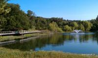
The southern trailhead features a boardwalk along the edge of a nice pond.

Request: The opposing parties in the controversy about the River Place Nature Trail feel strongly enough to try and express their opinions in the hike log entries. In part, this is because of the lack of a commenting functionality on the site. We hope to address this in the future. For now, we ask that you please leave hike logs for actual hikes and utilize the forum thread that discusses the closure of part of the trail.

Hiked just about every trail in the Austin area and looking for something new or challenging? The River Place Nature Trail just might be the trail you've been looking for.

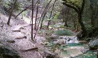
Much of the trail follows along stream beds through the canyon.

This new trail was created by the Municipal Utility District that serves the River Place neighborhood. In a word, the trail is fantastic. There are some steep elevation gains and descents that are mitigated somewhat by the ubiquitous placement of steps and stairs.

One of three trailheads are located on Big View Drive across the street from the tennis courts and small soccer fields. The trailhead here includes a nice kiosk detailing the trail map and animals that one might find along the trail.

The first section of the trail is a boardwalk that follows the boundary of a retention pond. You'll find lots of turtles here and sometimes folks that are fishing. The trail soon turns rough and disappears into the brush uphill.

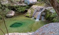
A few spots here and there feature nice waterfalls and interesting formations like this depression in the stream bed.

This first section of trail is referred to as Lower Panther Trail, named after the surrounding area, Panther Hollow. How did this name come about? When the area was still a working ranch several dead goats kept turning up near cave entrances. Ranch hands tracked down a Mountain Lion in this area thought to be responsible for the kills and dispatched it. There have been no Mountain Lion sightings in the area for quite some time.

The trail surface is hard pack and rock. It's uneven and often hugs the side of steep slopes above Panther Hollow creek. The trail builders used a lot of logs to buttress the downhill side of the trail for stabilization. It obviously required a lot of work to put this trail into place.

About a half mile into the hike there's a junction point that leads into two possible directions. To the right is the trail segment marked as Little Fern Trail. It leads to one of two trailheads along River Place Blvd.

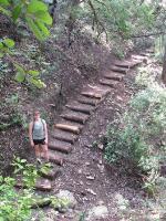
Did we mention that there are lots of stairs on this trail?

If one takes the Little Fern Trail option, there's is yet another another trail segment option. The Water Line Trail parallels Lower Panther Trail on the opposite side of the creek. Unlike the rest of the trail system, this segment is relatively flat and wide open to the sky. It's really more of a utility service path, but it's an option none the less.

The main option continues north and encompasses the newest addition to the trail system which includes trail segments entitled Upper Panther Trail and Canyon Trail. Here you'll find the roughest terrain with the biggest elevation variation. Expect quite a stairmaster-like workout as you descend into and ascend out of creek beds and ravines.

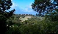
The northern portions of the trail feature a couple of vistas, otherwise your path is well sheltered by trees and brush.

The northern sections of trail also feature a few vista views of the surrounding canyon lands and the River Place golf club below. According to the official maps there are a couple of emergency exits onto the golf course along the northern trail segment.

The northern trail segment also empties out onto River Place Blvd. Although the River Place Blvd. trailheads lack explicit parking, there is space along the road to park.

In looking at the satellite views of the area it's quite possible that the trail system here could be expanded a bit further, though I have seen no plans put forward to do this. Whether the mileage gets increased or not, this trail is worth the visit.


Photos

Trailhead One of the two trailheads along River Place Blvd. (Photo by Austin Explorer) Stairs Stairs, stairs and more stairs. This trail has them. There are some nice benches on which to rest as well though. (Photo by Austin Explorer) Wooden bridges There are many wooden bridges throughout the "Lower Panther Trail" section (Photo by jtkatie)
Trail As you can see, the trail is well-constructed and well-used (Photo by jtkatie) Nice spot One of the lovely resting areas with what seem to be brand new benches (Photo by jtkatie) Stairmaster! The beginning of one of the most strenuous sections of the trail! (Photo by jtkatie)
The view! The view from the top of the hill is quite spectacular! (Photo by jtkatie) Mile marker The trail has very well-marked distances... although the gap from 1.5-2.0 on the way up seems a LOT longer! (Photo by jtkatie) Warning at the top trailhead Always a sign of great things to come when there are Emergency Exits off of the trail you are about to go on! (Photo by jtkatie)
Map of trail Featuring the Emergency Exits in red. :-) (Photo by jtkatie) Golf Course view A view from one of the higher points on the hike (Photo by jloop17) Small Pond One of the few times I saw water on the hike (not counting the times I was pouring my bottled water all over myself) (Photo by jloop17)
Texas Rocks Yeah I didn't do this, but it's pretty cool anyways (Photo by jloop17)

Log Entries

The whole upper trail is now closed
User: texaskdog - 6/11/2012  [View Log Page]
Rating: Difficulty: Solitude:
Distance: 2.00 Miles Duration: N/A

Whole upper trail from the junction to the north end is now closed.  The environmentalists won.  Don't bother going anymore.  Can still do the bottom stub until they close that too.

Did the north half
User: texaskdog - 3/29/2012  [View Log Page]
Rating: Difficulty: Solitude:
Distance: 3.00 Miles Duration: 1 hour, 15 minutes

We were going to do the loop starting on the south end but saw the closure so decided to start from the north.  You can actually go about 1.25 miles from the north, ending just after the longest staircase.  Not an ideal situation but at least we got a 75 minute EXHAUSTING hike in.  The species didnt die off since the trail opened, maybe they can just ban dogs from that portion, or maybe route the path along the edge of the golf course.  Birds aren't dumb, they'd move, there is plenty of room there that has no trail on it.  Be forewarned, other parks could be next (like at Forest Ridge)

My favorite hike ever
User: tarrains - 1/22/2012  [View Log Page]
Rating: Difficulty: Solitude:
Distance: 5.00 Miles Duration: 2 hours, 30 minutes

Be ready for STEPS.

User: kfergu3 - 1/13/2012  [View Log Page]
Rating: Difficulty: Solitude:
Distance: 3.50 Miles Duration: 2 hours

It's like Alice's underworld in some places! Other spots have great outlook views, and places to rest, or meditate. The coyotes and owls make their presence known out there (dusk). Watch your step for native lounging lizards! It's easy to lose yourself in the stairstepping--counting them is a fun challenge. Sometimes there are nice pools, where your barking dogs can cool off, and your canines. I ran into one guy who was doing one of those satellite scavenger hunts. Found out there's stuff hidden back there with log books! Pretty cool.

Hardest Trail in Austin - 2,866 steps
User: ullearn - 11/13/2011  [View Log Page]
Rating: Difficulty: Solitude:
Distance: 6.00 Miles Duration: 1 hour, 9 minutes
My wife and I were searching for a new trail and came upon this one. After hiking it we had wished we knew about this trail when we were training for the Grand Canyon Rim to Rim hike last year. We started at the top on River Place Blvd on the Canyon Trail down to upper then lower Panther trail. Once we reached the bottom we turned around and went back up. We enjoy a challenge hike slightly faster than average; took us 2 hours and 16 minutes to finish. There are 1,433 steps (one way), we thought it would be fun to count on the way back up; turned out to be a mental challenge. **Update** - Our 2nd hike their took us 1:58 minutes - Our 3rd hike we ran and finished in 1:09 minutes (36 up / 33 down)
Great hike for a cool day
User: Lou.Catozzi@att.net - 11/8/2011  [View Log Page]
Rating: Difficulty: Solitude:
Distance: 4.80 Miles Duration: N/A

I parked at the top of the side trail (Fern Hollow?) and hiked down to junction at Panther Hollow and then down to the pond and back up along the utility trail to the junction in Panther Hollow and then north up to the trailhead at the north end then south along River Place Blvd back to the Jeep so that is how I got my miles without any retracing of steps.

This is THE BEST neighborhood greenbelt trail I have seen in Austin. Such terrain, such scenery! It was neat to see the pools of water along sections of the trail, no doubt caused by run off from the golf course above the hollow. This will be an outstanding hike after we finally get some real rain here in Central Texas.

Beautiful but dry
User: TexasGal - 9/12/2011  [View Log Page]
Rating: Difficulty: Solitude:
Distance: 2.00 Miles Duration: N/A
Just learned of this trail from a friend and tried it out, starting from the 2nd entrance to experience the steeper climb in and back out. Really lovely trail, very narrow, but easy to follow. I was very surprised to find a few spring-fed pools and weeping grotto even in this record-setting drought. Duchess was thrilled to find a shallow pool to wet her feet and cool off. We are looking forward to returning to see the change of seasons.
Best elevation change hike in Central Texas
User: GUnit - 9/4/2011  [View Log Page]
Rating: Difficulty: Solitude:
Distance: 6.30 Miles Duration: 2 hours, 30 minutes
If you are looking for a challenging hike for Texas, then this is your hike. This is the hike you do to train for the Grand Canyon when living in Austin. River Place is 6.3 miles when you hike all the way to Lake Austin, just 6 if you go to the fountain at the bottom and back up. It was dry except for the fern wall, but I could tell this place is awesome when we are not in this serious drought.
User: lowburb - 7/2/2011  [View Log Page]
Rating: Difficulty: Solitude:
Distance: 6.00 Miles Duration: N/A
As tough as ever
User: jtkatie - 6/25/2011  [View Log Page]
Rating: Difficulty: Solitude:
Distance: 7.00 Miles Duration: 2 hours, 32 minutes

My wife and I had been working out for weeks prior to an international trip - for which we wanted to be in excellent shape. So, we packed up our backpacks (about 15 lbs each, but getting lighter as we drank water) and headed out for the toughest trail we have been on here in Austin. We pushed ourselves through the heat and made it through it in a respectable time.


Only showing last 10 log entries. View All Log Entries

Recommended Item

Recommended Item Best Hikes Near Austin and San Antonio (Best Hikes Near Series)
Keith Stelter
List Price: $18.95 Our price: $8.52 Buy Now
Featuring 30 of the best hikes in the greater Austin-San Antonio area, this exciting new guidebook points locals and visitors alike to trailheads within an hour's drive of Austin-San Antonio.