[ Log In ] or [ Register ]

McKinney Roughs

Trail (3.69)38
(2.66) (3.55)
17.90 Miles 1450 Feet
N/A Yes
Yes No
$4.00 More Info
Bastrop Bastrop
Take Action Bookmark and Share

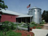
McKinney Roughs includes an extensive learning center and hosts many school groups to teach children about the environment.
Getting there: McKinney Roughs is located right on Hwy. 71 between Austin and Bastrop. From Austin, head east on Hwy. 71 past Austin Bergstom International Airport. Proceed for about 10-15 miles and look for the park's distinctive rock wall entrance with windmill on the left. Hiker check in is at the LCRA Office near the main parking area.

The Hike: McKinney Roughs contains the most extensive collection of hiking trails to be found in Central Texas. The official park website mentions over 15 miles of trails, with more planned in the future.

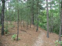
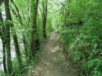
Pine needles litter the path of some of the trail. McKinney Roughs is on the edge of the Lost Pines.
All trails start at the waypoint marked "Trailhead" on the map. The exceptions to this are the two Equestrian trailheads that lie near the northwest and southeast corners of the park (not yet mapped). This main hiking trailhead is behind the red Environmental Learning Center building.

The easiest trail in the park, the Ridge Trail is shown on the topo map in blue to make it easy to find. The trail is mostly flat with a smooth surface of crushed granite. Someone was in the process of creating an interpretive trail guide for this path during my last visit and I was able to borrow an advance copy to take along. Unlike many interpretive guides, this one went into some interesting details about the coexistence and synergy between many of the species and plants and animals that call McKinney Roughs home.

The trails of McKinney Roughs undulate up and down hillsides.
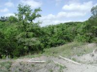
The remaining trails are a criss-crossed collection of full and partial loops that provide ways to craft almost any type of hike you could want. The trail surfaces consist of rocky hardpack in the uplands and dirt and occasionally sand along the river's edge.

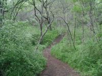
As the trail lowered to the Colorado River the extra moisture fed a thick carpet of greenery.
Most of the tree cover at McKinney Roughs consists of the Juniper-Oak combination that is commonly found throughout the hillcountry to the west. But this land is on the very outer edges of the Lost Pines area and some stands of pine can be found, particularly on the east side of the park.

Flat portions of the trails are often marked by pocket prairies. These spots of open land are a treasure trove of wildflowers. One of the better areas for wildflowers of all varieties was the pocket prairie along the Bobcat Ridge trail just west of the main entrance driveway.

The trail follows along the bank of the river for about a mile.
As trails descend to the river the surrounding vegetation closes in on it. The path narrows considerably and the wildflowers disappear. Instead the ground is covered in a thick carpeting of various grasses, all very green.

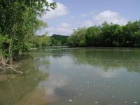
The Colorado River as seen from the trail.
Most of the trails at McKinney Roughs allow for horseback riding. If being near an occasional horse is intimidating you can avoid them altogether by limiting your hike to the Ridge, Woodland, Cypress, Pine Ridge, Valley View and Bluff Loop trails. These total over 5 miles, approximately one third of the park's total trail system.

Don't be afraid of the horses and let a majority of the park go unhiked! When coming up on a horse and rider, stand on the side of the trail motionless and gently chat with the riders as they pass by. As has always been my experience at McKinney Roughs, the riders are friendly and considerate.

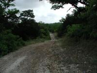
Some portions of the paths are old jeep trails.
The trails on some of my visits had an unfortunate trait that I had not anticipated - cobwebs. Lots of them. Spiders find that by spanning a sticky web across a open area like a trail they can capture more frequent meals. What it meant for me was a frequent brushing of my arms and legs to free myself from the web's snare. Eventually I adopted a long branch, which when waved in front of my direction like a royal sceptor cut down on the number of web collisions. But sometimes the method served only to break the silky stand, which willowed in the wind and stuck to the first available object, often my clothes or skin.

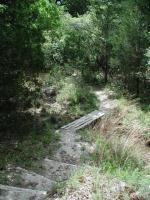
No creek crossing on the trail presents any problems and often includes a bridge, such as this one.
Added to the spider webs were catepillar strands. Hanging under oaks like bungee jumpers the little green guys contributed to making the going slow as I tried my best to clear a path. I'm sure that fellow hikers who followed my path later in the day reported far fewer web encounters. Don't let this tidbit scare you. Spring is bound to include more activity with respect to spider webs and caterpillar strands. Hiking at different times of the year may avoid this hassle.

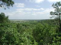
Further uphill there are several magnificent views of the Colorado River below. Note the farmland on the flatter land on the opposite side of the river.
A wonderful view of the Colorado River is available at the waypoint "Overlook". The view shows some of the contrasts in the land here. To the right of the river the hilly terrain continues and is heavily forested. On the opposite bank the land is relatively flat and since it is more conducive to being farmed it has been cleared.

The McKinney Roughs trail map does not make any mention of ranch ruins along the trail. According to the information center the property was a working ranch having first been settled by John Wise and his family in the 1850's. The Wise family continued to live on the property up until the 1950's when the family home burned down. The remains of a corral can be seen at the waypoint "Corral" and what may be the location of the Wise home can be found along the trail not too far afterward. All that remains of the home now is a concrete slab and chimney.

Although McKinney Roughs bears the name of Thomas McKinney, there is no proof that he either lived there nor owned any of the land. However, he did own a lumber mill across the river and may have used some of the trees cut down within the boundaries of the current park.

Though somewhat saddened by the sale of the northern half of the park, McKinney Roughs remains a prime hiking destination in the central Texas area. The complex system of trails can be difficult to comprehend in the beginning but provide a plethora of options that allow visitors to set up exactly the kind of hike that they desire.


Photos

Boggy path This path is along the Riverside section of the trail. The trees are quite dense in this area as you can see. (Photo by schrochem) Twisty path On the Cypress trail the path gets pretty twisty b/c it is hiking only. (Photo by schrochem) Terrace These seemed to be placed at trailheads where only hikers were allowed. Evidently, horseriders would have to duck to get past. (Photo by schrochem)
Heading down the river trail (Photo by seejanplay7) Colorado River seen from the trail. There is a picnic table here along the banks. (Photo by seejanplay7) Colorado River access. It is possible to walk out on the rocks here. (Photo by seejanplay7)
McKinney Roughs Very nice view of the Colorado River from the Overlook. (Photo by Eveline) McKinney Roughs Visitor Center Check in here to hike. They require all hikers to register and carry a map. This is a good idea because there are a lot of options to consider. (Photo by wdoud) Distance Marker on Ridge Trail Wooden markers like this appear on some trails; they are 100 feet apart. Other (longer) trails have metal markers at 1000 foot intervals. (Photo by wdoud)
Trail Junction Trail junctions and directions are well marked. (Photo by wdoud) Metal Posts Mark 1000-foot Intervals (Photo by wdoud) Zoey! Zoey's a great hiking dog and she strongly recommends McKinney Roughs (Photo by estudio64)
Fire Damage A view from the trail showing some trees that had burned in the 2008 that hit part of the park. Note the lush vegetation growing up and rejuvenating the area. It's coming back. (Photo by Austin Explorer) On the trail Here I am on the trail heading downhill. (Photo by Austin Explorer) Colorado River Looking down on the Colorado River from the Bluff Trail Overlook. If you close closely enough you can see someone's horse (I think!) wading in the water below. (Photo by Austin Explorer)
Trail View The long a straight trail here beckoned me to complete it and mark it off my list of trails to do here. (Photo by Austin Explorer) Taking a Dip A horseback rider leads his horse and another riderless horse into the Colorado River for a shallow dip. (Photo by Austin Explorer) Entrance Sign This is the sign at the entrance of the park off Hwy 71. (Photo by Lone_Star)
Colorado River This scenic overlook provided a nice view of the Colorado River. (Photo by Lone_Star) Massive Pecan Tree This pecan tree is massive! Note the size of the picnic table next to the base of the trunk for scale. (Photo by Lone_Star) Cactus Flowers The cacti were in full bloom. (Photo by Lone_Star)
Snakes These cottonmouths were sunning on a rock along the trail. (Photo by Lone_Star) Wildflowers Wildflowers were in full display along the trails. (Photo by Lone_Star)

Log Entries

User: ValEpiscopo - 5/11/2013  [View Log Page]
Rating: Difficulty: Solitude:
Distance: 8.00 Miles Duration: 3 hours
Hiked Riverside, Bluestem, Cypress, part of Pine Ridge, Bobcat Ridge, Foxtail, part of Ridge, Woodland, part of Bluff Trail Loop, part of Coyote Road, and a portion of Youpon trails.
McKinney Roughs (Day 1 of 2)
User: Lone_Star - 4/27/2013  [View Log Page]
Rating: Difficulty: Solitude:
Distance: 9.60 Miles Duration: 4 hours, 9 minutes

I hiked McKinney Roughs Nature Park with a group over a 2 day weekend.  This log covers the first day.  The 2nd day log of the other trails in McKinney Roughs can be found here.

We started near the Visitor's Center and hiked various trails around the Nature Park and along the Colorado River.  The trails are very well-marked and maintained.  Some are for hiking only and others double as equestrian trails, so expect a lot of horse poop.  Mountain bikes are not allowed, however, which is kind of nice as it reduces the overall traffic and collision potential.

The trails were flanked by very lush, green vegetation, including some nice specimens of cactus.  I spotted two cottonmouth snakes sunning on a rock and was impressed by a couple of HUGE pecan trees.  The trail surface is rocky in several spots, so its a good idea to wear good boots to avoid blisters and twisted ankles.

Finishing up mapping of trails
User: Austin Explorer - 12/9/2012  [View Log Page]
Rating: Difficulty: Solitude:
Distance: 9.25 Miles Duration: 3 hours, 40 minutes

I came today to knock the remainder of the trails at McKinney Roughs that I'd not done during my previous trips.  I think now I have all of them.  Track file for this log will include only what I did today.

The overcast skys might have prompted some folks to stay home, so there were not too many people on the trails.  More horseback riders than hikers.  Also note, that the main visitor center is closed on Sundays, so if you want to visit you have to start off from either the Hwy. 71 or Pope Bend Rd. trailheads.

Back for more
User: Austin Explorer - 9/23/2012  [View Log Page]
Rating: Difficulty: Solitude:
Distance: 8.53 Miles Duration: 4 hours, 38 minutes

Coppertone and I headed back again to map out the northern half of the park.  Good thing too, because the main visitor center is now closed on Sundays so we had to drive to the Pope Bend Trailhead.

What we found out on this hike was that Coppertone is not fond of horse poop!  She doesn't mind the horses, just the excrement.  When we hike together we might need to stear clear of trails that are shared use.

The Yaupon Trail segment is the newest in the park.  I think it was put into place when the Hyatt Lost Pines Resort took over the north part of the trail and the previous trail in the area became the resort entrance.

It had been years since we had hiked the northern part of the park and things seemed more overgrown and closed in than before.  I think we recalled some more open meadows in the past.

Trails galore!
User: Austin Explorer - 9/3/2012  [View Log Page]
Rating: Difficulty: Solitude:
Distance: 7.14 Miles Duration: 3 hours, 37 minutes

I've lost track of which trails we've done at McKinney Roughs and which we haven't.  So I figured that we'd just start from scratch and start mapping them all.  This is certainly not a one day job, particularly when the temps could get to 100 degrees.

Only ran into three or four couples on the trail.  We almost saw more horses on the dual use trails than people overall.

I had failed to realize how long it had been since I was last at McKinney Roughs.  On the Pine Ridge Trail I hadn't expected to see some of the remaining fire damage from some fires that went through part of the park back in 2008.  Things are coming back, but the scars and dead trees in places are still evident.

We were fairly well spent after 7 miles and the heat rising. Mapping the rest of the trails will have to wait for another visit.

Wonderful Scenery in a Beautiful Park that's Worth the Price
User: estudio64 - 3/14/2012  [View Log Page]
Rating: Difficulty: Solitude:
Distance: 4.00 Miles Duration: 3 hours, 30 minutes
On Tuesday, we adopted our new dog, Zoey, and on Wednesday, decided to test her mettle with a 3.5 hour hike. The verdict: she loved every step of it, and so did we. The vistas, especially Meditation Point, offer spectacular views of the Colorado River and its surrounding landscape. We also visited the Large Pecan Tree which appeared to live up to its name. 200 years old - goodness gracious. Recent rains left the trails quite muddy, but the scenery was so lovely that we hardly gave it a second thought. The mud offered some easily identifiable tracks, although the only wildlife we saw were hawks lazily sailing overhead. The dog's a keeper, and so is this beautiful LCRA park.
Well worth the drive from North Austin
User: texaskdog - 10/3/2010  [View Log Page]
Rating: Difficulty: Solitude:
Distance: 5.00 Miles Duration: 1 hour, 40 minutes

Been wanting to do this one for a year.  So many paths to choose from we asked the nice lady at the desk for recommendations (BTW it is $4/person now but well worth it).  She suggested Pine Ridge to Cypress to Riverside, then back on the Ridge.  Will take 2 more visits to do them all.  Not too many ups and downs and no water crossing, but closest hike to anything in Michigan or South Dakota's wooded areas I've found yet.

Great trails
User: BKanten - 2/20/2010  [View Log Page]
Rating: Difficulty: Solitude:
Distance: 3.25 Miles Duration: N/A

The trails are well done, with a combination of dirt and gravel that makes for easy walking. The difficulty comes in the elevation changes on some portions but nothing too bad. Plenty of plant diversity. We saw some prickly pears putting out fruit, which was neat, and the flowers were starting to appear. Recent rain made for mud on some portions but the good trail bed limited the problems here. Solitude was less than usual because we walked during an organized event (www.ava.org); usually there are few people on the trails. There are a lot of trails and plenty of distance.

park hours wrong on this site
User: sandew - 5/24/2009  [View Log Page]
Rating: Difficulty: Solitude:
Distance: N/A Duration: N/A

Sunday noon to 5.  Went to hike on Sunday, at 10am, but not open til noon and with the heat, didn't wait....instead went to Bastrop State Park which was open, just down the road off 71.

Nice enough
User: claireBGC - 5/18/2009  [View Log Page]
Rating: Difficulty: Solitude:
Distance: 3.50 Miles Duration: N/A

We did parts of the Woodland, Ridge, Riverside and Bluestem trails, adding up to about 3.5 miles.  There are some nice overlook points and we saw very few people.  It was somewhat muddy as it had rained just a couple of days before, but the trails were well marked and maintained for the most part.  The Colorado is not the prettiest river to hike along, but overall a good short hike.  Very shady for the most part, which would be nice in the Texas summer.


Only showing last 10 log entries. View All Log Entries

Recommended Item

Recommended Item Hiking and Backpacking Trails of Texas: Walking, Hiking, and Biking Trails for All Ages and Abilities
Mickey Little
List Price: $19.95 Our price: $10.69 Buy Now
A guide for hikers and backpackers seeking adventure throughout Texas with detailed information on location, facilities, activities, special features, layout, fees and cautions. Photos give the flavor and attractions of many of the sites.