Inks Lake State Park

Trail (3.93)
(2.62) (3.38)
7.00 Miles 750 Feet
N/A No
Yes Yes
$4.00 More Info
Burnet Burnet
Loading...
Larger Map

Inks Lake combines a little used hiking trail with interesting granite outcroppings along its path. (Click on map for larger view)
Maptech® USGS Topographic Series™, ©Maptech®, Inc. 603-433-8500, www.maptech.com/topo Copyright 2000 Maptech, Inc.

Getting there: From Austin head north west on Highway 183. Turn left and head west on Highway 29. Turn left on Park Road 4 and proceed south for about 3 miles to the Inks Lake State Park headquarters. Trailhead parking is located a few hundred feet behind the headquarters in the separated parking area.

The Hikes: Inks Lake is one of the smaller Highland Lakes that were created by the dams that the Lower Colorado River Authority created in Central Texas. At one time I was not too sure that the relatively small park, with some of its acres taken up by a golf course, would provide much in the way of hiking. Friends who had been at the park testified to it's virtues, but theirs interests were in the golfing and boating opportunities. A closer inspection of the park's trail maps provided some hope, though the map did not provide a full representation of the trail due to the map's layout, so some uncertainty remained. After hiking a good portion of the trail system at Inks Lake I now know that this park does provide much for the hiker, a whole lot more than I originally expected.

The trailhead resides at the back of the loop road that encircles the park lake.
The hike started at the waypoint marked "Trailhead". This is conveniently just a few hundred feet from the main ranger station at which one pays the park entry fee. The trails at Inks Lake feature trail maps carved into wood at several major trail junctions and here at the trailhead. A posted sign indicated that the park is experimenting with a way to mark trails using colored tape. It's not clear whether the experiment is contiuing as I did not notice much tape along the trail.

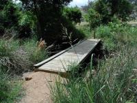
The only creek crossing of any significance includes a bridge.
The trail gradually descends toward the south and brushes against the shore of Inks Lake before turning more to the southwest. Along the lake shoreline it becomes apparent that the most striking feature of Inks Lake is the abundance of granite rock outcroppings. Large boulders either litter the landscape or huge domes of granite burst from the Earth like a permanent bubble. At times the trail can be slightly hard to follow when it traverses the granite outcroppings because even the feet of thousands of hikers does little to wear down the stone. Look for lines of rock that previous hikers have laid down as a guide until the trail becomes more apparent.

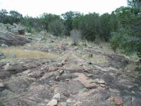
This photo sums up the hike at Inks Lake. There's brush, there are trees and cacti and there's lots of bald rock.
After the initial waypoint marked "Y-Left" the turns tend to be rather simple for some time. In an effort to extend the hike keep choosing right turns where possible until almost the end of the hike.

Because of the large number of open spaces due to rock outcroppings one must take care to protect oneself from sunburn while on the trail. There are few densely wooded areas along the trail, but they are not the norm. When not scampering over bare rock the trail typically meanders through scrub oaks and Mountain Juniper, typical Hillcountry flora that also expose hikers to plenty of direct sunshine.

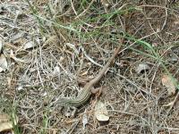
We saw a large number of these lizards along the trail. Most ran off into the underbrush when approached. This one was a bit more curious.
The waypoint "Overlook 1" marks the first spot of many that provide fantastic views. Here one can look down on the Hylton Branch arm of Inks Lake and some of the park land on the opposite shore. A huge granite outcrop dominates the view. Although somewhat reminescent of Enchanted Rock this batholith pales in comparison when it comes to size. Chances are one would encounter far fewer people upon reaching the top however.

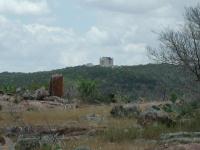
Views of nature are not the only things to be seen from the trail. Here's a castle, right here in the Hillcountry.
The "Road Cross" waypoint is not very dangerous. The amount of traffic is not excessive and drivers typically keep their speeds under control since they are enjoying the sights around them. But this also means that they are likely not on the lookout for hikers. So proceed across the road with caution.

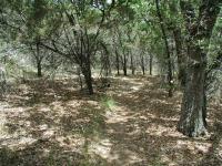
There is some shade during the hike such as this section, but open skies are more of the norm. So wear your sunscreen!
As is often the case, the back portion of the hike is the most enjoyable. The vegetation is slightly heavier, particularly towards Peter Creek, so there is more shade that elsewhere. However the reason why this part of the hike is more enjoyable is because the trail moves away from the park road, lures fewer visitors out to its periphery and includes some stunning views and rock formations.

Like Enchanted Rock, Inks Lake is home to plants that find a way, somehow, to find a cool, shady place in which to grow.
Towards the southern-most part of the hike look in the general direction to the east and catch a glimpse of a castle. Yes, a castle. Someone os well-to-do means has built an enormous castle on a high hill off in the distance. It's not every day that you see such an edifice in Central Texas.

Occassionally it's hard to follow the trail when it crosses rock outcroppings. Previous hikers have made the way more apparent with guiding lines of stone.
At the waypoint "Two Rocks" the trail passes between huge granite boulders. The undersides of the boulders appeared to have an odd shadow, which upon closer inspection turned out to be the largest group of Daddy Longlegs I have ever seen. Several colonies inhabited every facet of the boulders that provided a cool retreat from the Sun. Not only were these colonies holding an enormous number of Daddy Longlegs, but they were also very densely packed with bodies against the rock and their long legs bend upward.

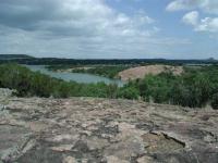
Along the trail are several great views of Inks Lake. This spot sits on a granite dome and another dome can be seen across the water.
After several right turns, we turned left at the waypoint "Y-Left". This shaved perhaps a mile from the hike as the trail to the right would have looped around the primitive camping area. Not far down the trail, the second overlook on the hike at the waypoint "Overlook 2" provides a view similar to that available at "Overlook 1". The perch here is somewhat higher and farther back from the lake.

Two large granite spires loom overhead through the trees along the trail.
Toward the end of the hike I heard a slight rustling in the brush and paused to try and get a bearing on its source. After a few moments I spied an Armadillo about 15 feet away foraging through the leaf litter and completely uninterested in our presense. By the end of the hike we had spotted an armadillo, deer, road runners, several lizards, grasshoppers too numerous to count and several different species of bird. It provided one of the most abundant collections of wildlife that we've seen in the area.

The waypoint "T-Left" marks the homestretch for the hike. The trail heads west, crosses Park Road 4 one more time and then rejoins the trail followed on the way out soon thereafter. Follow the trail back to the north towards the trailhead to complete the hike. This writeup describes a loop of approximately 5 miles. A few feeder trails and a loop extension that leads to the west to the primitive camp ground increases the length of the Inks Lake Trail system to the park reported 7 miles.

Inks Lake provides a rewarding hike on many different levels. The back trails are reasonably quiet and remote despite the trail's proximity to Park Road 4. There's an abundance and variety of wildlife to watch and there are plenty of rock ourcroppings over which to crawl and climb.

Granite Daisies

(Photo by BlazerMan)
Greater Earless Lizard

(Photo by BlazerMan)
Devil

(Photo by BlazerMan)
Lichen covered Granite

(Photo by BlazerMan)
Granite Exfoliation

(Photo by BlazerMan)
Castles

The Falkenstein Castle is in the background. (Photo by BlazerMan)

Logs

Have you visited this location? What did you think of it? Submit your own log entry to let others know of your experiences and to keep track of your adventures.

User: wesrader - 1/15/2010  [View Log Page]
Rating: Difficulty: Solitude:
Distance: 5.00 Miles Duration: 2 hours, 30 minutes

This is a great hike, especially when you cross the highway and get up into the isolated hills and rocks.  Lots of climbing and great views of  Inks Lake and the surrounding hills.  Inks is a great place to camp too, with lots of things to do.

Green loop
User: Riff Raff - 1/9/2010  [View Log Page]
Rating: Difficulty: Solitude:
Distance: 2.50 Miles Duration: 2 hours

Attempted to take the green loop on this cold weekend (there was still some ice in a few places). Had some trouble staying on the trail since I hadn't initially noticed the green dot markers painted on the rocks in the more sketchy areas. Very nice, rugged area.

Had to walk off turkey
User: ems330 - 11/28/2009  [View Log Page]
Rating: Difficulty: Solitude:
Distance: 1.50 Miles Duration: N/A

My wife and I took our 15 month son on part tof the green trail. It wasn't marked very well so ended up just finding way back to road then to parking lot.  But was good was to get out of house and walk off some of Thanksgiving dinner.

Great Hike
User: Fievel121 - 3/16/2009  [View Log Page]
Rating: Difficulty: Solitude:
Distance: 1.50 Miles Duration: 30 minutes

Plesant, with plenty of hills & lots of cactus. Spring is the perfect time for this hike

Granite and heat
User: caspalding66 - 10/25/2008  [View Log Page]
Rating: Difficulty: Solitude:
Distance: 4.50 Miles Duration: 2 hours
Great granite outcroppings and views, still hot in october
User: M High - 3/16/2008  [View Log Page]
Rating: Difficulty: Solitude:
Distance: 5.00 Miles Duration: 3 minutes

Trail is very well marked (except for some of the green trail, where I have to do a little bit of trailfinding).  Easy hike, very little change in elevation, only saw a couple dozen people on a Sunday afternoon.  But civilization was never far away, lots of road traffic noises during most of the hike, plus powerlines. 

Awesome view, Fun Hike
User: hawaiiantaz - 3/2/2008  [View Log Page]
Rating: Difficulty: Solitude:
Distance: 7.00 Miles Duration: 2 hours, 24 minutes

A friend and I started our hike shortly after the park opened this day... shortly after starting we stopped by the lake to watch some water fowls playing.  Trails were easy to follow and the outcropping of rocks/granite made the hike interesting.  The trail along the outcroppings are clearly marked either with colored paint dots or with rocks layed out forming a path.  I saw a couple of large lizards (they wouldn't stick around for me to take pictures of them though).  The whole time we hike, we were the only 2 people on the paths... loved it and would hike here again!!

short but pretty hike to Devil's Watering Hole
User: haggai - 11/10/2007  [View Log Page]
Rating: Difficulty: Solitude:
Distance: 3.00 Miles Duration: 1 hour

Plenty of opportunities for bouldering, cooling down in the water, and enjoying the scenic, rocky countryside.  Watch out for snakes.

Enjoyable
User: jsr59jsr - 7/31/2007  [View Log Page]
Rating: Difficulty: Solitude:
Distance: 7.00 Miles Duration: 3 minutes
Fabulous Camping
User: perk1963 - 6/11/2007  [View Log Page]
Rating: Difficulty: Solitude:
Distance: 30.00 Miles Duration: 14 hours

We camped near Devil's Swimming Hole for several days.  The weekend would have been unmanagable due to the crowds we witnessed even late on Sunday, but Monday was a whole different story and we loved it.  We covered all of the trails available, some several times.  My dog was helpful when some of the trails became questionable, keeping us on track.  We saw several deer on the trails, and scores in the park.  My difficulty rating encompasses the difficulties in determining trails,occasionally, and he searing sun, even early in the morning.  The views are worth it, hands down.  Wear a hat.  Clearly my favorite place to hike in this area, with or without camping.

Wildflowers everywhere...
User: lordvallsbyrd - 5/19/2007  [View Log Page]
Rating: Difficulty: Solitude:
Distance: 5.00 Miles Duration: 2 hours
This was a nice, enjoyable hike through the hill country with beautiful wildflowers in bloom everywhere. Only saw one other person on the trail but due to the area this park is in it only gets a three for solitude.
Not deep wilderness but some nice country side
User: BrianJ - 1/28/2007  [View Log Page]
Rating: Difficulty: Solitude:
Distance: 7.00 Miles Duration: N/A
Good Stuff. Only people I saw was one family of 5 coming off the trail as I was coming on. The Park HeadQuarters will hand you a map that marks off three short trails in Green, Yellow, and Blue. No trail names just the colors! Anway you can hit all three trails by changing paths at the connectors. Probably about 7 miles total. No real elevation change and it definitely didn't feel like deep wilderness solitude since you can see houses and roads on all of the vistas. Nonetheless a nice quick 2 hr in and out hike.Scenery: Bright colors on the rocks, 3 deer, and there was one interesting plateau that was swarming with prickly pear.
HOT!!
User: big tex - 5/30/2006  [View Log Page]
Rating: N/A Difficulty: N/A Solitude:
Distance: 7.00 Miles Duration: N/A
Never do this hike in the summer. It's hot and the trail is a bit confusing so tempers can get out of hand. My group of 4 split up at one point due to an arguement. Devil's water hole was fun though jumping off the cliffs.
User: LVX - 4/23/2006  [View Log Page]
Rating: Difficulty: Solitude:
Distance: 8.20 Miles Duration: N/A
Going after Rocky Bluff we were able to extend this 7 mile hike a little further. Great hike! It rained quite a bit the past week so there was a great deal of color along the trail. Not to difficult and a great morning. L
One of the best hikes within 60 miles of Austin
User: figment - 3/6/2006  [View Log Page]
Rating: Difficulty: Solitude:
Distance: 5.00 Miles Duration: N/A
Inks Lake State Park has some great Central Texas hiking. The hike is mostly along pink granite, similar to Enchanted Rock's Loop trail, and unlike almost any other trail in Central Texas (most are rocky with limestone). In addition, the trail follows the contours of the lake for stretches, ensuring a beautiful view. I took the outside edge of all of the trails in the park, including a diversion through the hike-in camping area. Didn't see any tents back in the primitive camping area, but it would be a nice place to camp.
Loved the terrain and the wildlife.
User: BlazerMan - 3/4/2006  [View Log Page]
Rating: Difficulty: Solitude:
Distance: 10.00 Miles Duration: N/A
I spent the day out hiking the green, blue, yellow, and red trails in order to map them with my GPS for the Central Texas Challenge team. The team used the data to make some hiking maps: topo and aerial.

Austin Explorer, I hope you don't mind that I used some of your waypoints for reference points on the map.

I've got flickr photosets from around the state park and from the challenge.
Relaxing Hill Country hike
User: yeiyel - 3/2/2006  [View Log Page]
Rating: Difficulty: Solitude:
Distance: 7.00 Miles Duration: N/A
You gotta love that hill country. The colors were beautiful, the weather was perfect, the views were wonderful. There is alot to admire during this hike. We were on the trail by 9:00 am, saw one person on the trail until the very end. The last 1/4 mile we must have seen 50 people.
Day Hike At Inks Lake
User: Miles - 1/21/2006  [View Log Page]
Rating: Difficulty: Solitude:
Distance: 4.50 Miles Duration: N/A
Had not been on these trails in Quite some time! It was nice to be back. I had forgotten just how beautful this park really is! I guess now, with the dry weather, is a good time to hike these trails. No snakes!! The lake is low, so you can hike in places that you ca'nt, due to higher water levels! Nice day trip from Austin. Try it You'll like it!
Lots of views, excellent rock formations
User: Soonhorn - 1/21/2006  [View Log Page]
Rating: Difficulty: Solitude:
Distance: 5.70 Miles Duration: N/A
We hiked from the trailhead and then went left at each junction. At the junction of the red and yellow (go left on the small yellow trail), go on top of the granite mound and you will have views of the castle. Take binoculars, this hike gives you lots of long views. We took the yellow trail over to the second red trail then over to blue trail then cut left onto the green trail back to the trailhead. Get a hiking map at the ranger desk. On the large blue trail there is a canyon with a powerline crossing it. You can cut across there and connect back to the trail. If you are adventuresome. You will see some neat deer blinds and great rock formations that make you stop and think "how did they get here like that?". Look at all the spanish daggers ( the large yucca plants) there is one near the end of the blue trail that is about 12-14 feet tall. It is something to see. We took a lunch on the large granite flat just past the second crossing of the powerline overlooking the lake. Overall, Really nice. Many places along the way, you have that feeling that a cougar could jump out of the rocks...it is really cool.
Great hike with the dogs!
User: gwenmotz - 7/9/2005  [View Log Page]
Rating: Difficulty: Solitude:
Distance: 5.00 Miles Duration: N/A
My husband and I hike with our dog and a dog we're watching for the next few days. We had a great time even though the temperatures were in the 90's. We all enjoyed a dip in the lake afterwards.
First Hike w/ family
User: Joefirefighter - 5/25/2005  [View Log Page]
Rating: Difficulty: Solitude:
Distance: 2.00 Miles Duration: 1 hour, 30 minutes

This was the first hike I took with my young family on our first family camping trip.  We did not hike the entire loop.  The  hike was fairly easy and the kids had a great time looking for the blazes.  In fact, there was a bit of an argument over who would get to be in front and find the trail. 

Warm and Mostly Quiet
User: txhipowr - 7/26/2004  [View Log Page]
Rating: N/A Difficulty: Solitude:
Distance: 7.00 Miles Duration: N/A
It looks like I did the same maximum loop hike as described last Saturday. I arrived at the park about 8:00am and only met a few people out on the trails. There were several different groups in the primitive campsites. While visiting the Pecan Falls geocache I listened in on a group of boy scouts setting up camp just thru the trees nearby. That sure brought on a rush of memories. Was I that loud and silly at that age?!?
Nice hike while I was camping there
User: HikerGirl - 8/2/2003  [View Log Page]
Rating: N/A Difficulty: Solitude:
Distance: 2.50 Miles Duration: N/A
It was a hot, August day but I did a little bit of the trail and then hit the water afterwards! Will be going back in Oct to do this again!
Must come back when it isn't so hot!
User: ltubbs - 7/27/2002  [View Log Page]
Rating: N/A Difficulty: Solitude:
Distance: 2.50 Miles Duration: N/A
This trip was another checkout for an upcoming Grand Teton trip. I reconfigured my pack and I think I have it riding very well. We didn't due the outer loop since we'd day-hiked around the lake all day and since we got started about 7pm. We did one of the smaller loops and set up camp for the night. The trail was GREAT and I must get back out here when it gets cooler to do the entire outer loop. If you visit the park, be sure to come early and visit the Devil's Waterhole area. This area is right where the lake opens up (the opposite end of the park from the trails described here). The river is passing through a rather tight canyon of metamorphic gneiss (very old, hard crystalline rock). Do yourself a favor and put on your hiking sandals and hike up this canyon about 1/2 mile to a nice cascade. It also makes for a great way to cool off after the longer loop hike described above. This area reminds me of the slickrock regions of northern Arizona or southern Utah. There is it sandstone and here it is gneiss, but either way it is beautiful.
One of the best hikes in Central Texas
User: Austin Explorer - 6/8/2002  [View Log Page]
Rating: Difficulty: Solitude:
Distance: 5.35 Miles Duration: N/A
My girlfriend and I enjoyed this hike more the average outing. Despite the hot temperatures the rolling terrain over domes of granite are both interesting and challenging. Despite crossing the road a couple of times we encountered few people on the trail. In the back part of the loop it seemed like we had the whole park to ourselves. Throw in lots of bird and animal sightings and you have the recipe for fun hiking.
Very Nice.
User: Eveline - 4/27/1996  [View Log Page]
Rating: Difficulty: Solitude:
Distance: 12.40 Miles Duration: N/A
Lots of big rocks and cactus.

Recommended Item

Recommended Item Official Guide to Texas State Parks (Learn About Texas)
by Laurence Parent
List Price: $21.95 Our price: $13.94 Buy Now
Whether you enjoy looking at scenic landscapes, touring historical sites, camping, fishing, hiking, backpacking, swimming, boating, horseback riding, rock climbing, or almost any other outdoor recreation, there's a state park in Texas where you can pursue your pleasure. From the Panhandle to the Rio Grande Valley, the Pineywoods to the Big Bend, some 125 state parks offer you a natural escape from fast-lane living. This book is the only official and complete guide to the state parks of Texas. Loaded with accurate, up-to-date information from the Texas Parks and Wildlife Department, it describes the attractions of each park and gives details--including a locator map--about camping and lodging facilities, types of recreation offered, and addresses and phone numbers for more information. To assist you in planning trips, the parks are grouped into seven geographic regions--Big Bend Country, Gulf Coast, Hill Country, Panhandle Plains, Pineywoods, Prairies and Lakes, and the South Texas Plains. With gorgeous color photographs and an inviting text, Laurence Parent depicts the natural features and attractions of each region. So if you want to watch the sunset over Enchanted Rock, fish in the surf on the beach at Galveston, or listen for a ghostly bugle among the ruins of Fort Lancaster, let this book be your complete guide. Don't take a trip in Texas without it.