-small.jpg)
The trailhead.
From Austin head west on Highway 290. After near 30 miles
turn north on RM 3232. Continue north until 3232 dead ends into a T-section in the road.
The entrance to Pedernales Falls State Park is to the right off of FM 2766. Upon entering
the park continue, drive approximately 3 miles and take the second right turn after the park
headquarters building. Take the second left turn in the camper parking area and continue
to the T-section at the back of the camper area where there are a few parking spaces for hikers.
The Hike: If Pedernales Falls State Park has a wild side, the 4 Mile Loop trail
is it. While not particularly rugged or remote by backcountry standards, the trail's position on the
opposite, unbridged river bank from the rest of the park serves as a filter for the vast majority
of park visitors. Considering how easy it is to get across the river this says much more about
the people who visit the park rather than the trail itself.
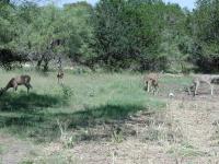
These deer were initially startled by our presense, but quickly returned to their foraging.
The day's hike begins at the waypoint "Trailhead". Our first surprise of the day occurred literally within feet of the beginning of the hike. As we passed by a Cedar tree we startled, and were startled by the presence of, five deer feeding on a patch of grass that had been mowed recently by the park. Once the initial shock subsided the deer went back to their grazing about 50 feet from us. We stood there silently for a couple of minutes until the child of a camper noticed the deer, but not us, and promptly charged after them on his bicycle while bellowing the less than endearing chant, "kill the deer!" The river crossing could not come soon enough for us.
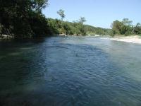
The Pedernales River, looking upstream from the trail crossing point.
Rivers are often differentiated from creeks by whether there are tributaries that run into them.
By this definition the Pedernales River is indeed a river. By the standards of how much water flows
between its banks the Pedernales on our the day of our trip might better be termed a large
creek. Don't be fooled for a minute that this unassuming body of water can not pack a punch
when conditions are right. The condition of the river banks provide ample proof of that.
-small.jpg)
A view from the trail, looking back down to the Pedernales River.
I had hiked the 4 Mile Loop several years ago. On this trip, when I got toward the banks
nothing looked familiar. Nothing at all. When we approached the actual river crossing I
recognized the place immediately and saw the signs of momentous change. Areas
that had been heavily covered were now sandy and grassy. Huge trees that towered over the area
were knocked over or gone. Those trees that remained bore markers to show just how big the
little Pedernales could be. Above our heads log and brush debris marking the highpoint of a
flood that must have crested 20 feet or more above the current water line and well above our
heads. The Pedernales is typically small, but she can pack a punch after heavy rains.
The river crossing requires wading in the cool and moderately rapid waters as they rush over a
smooth rock surface. Rather than a chore to be dreaded, the crossing is a refreshing treat and
will be again on the return journey.
-small.jpg)
Much of the 4-Mile Loop follows old ranching jeep trails.
Once on the far side of the river, the hiking begins in earnest. The trail leaves the rocky
river bed and climbs immediately upwards. After about 50 feet of ascent the trail levels off
somewhat and continues east.
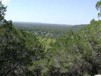
The main 4-Mile Loop trail does not contain many scneic vistas, but a short side trail along the way has some like this one.
One of the reasons why the 4 Mile Loop may not be as popular a hike is the trail condition. It's
usually easy to follow, but is typically not marked, save for a few trees with painted while
blazes. After a summer growing season a good portion of the trail was overgrown with grasses
that swiped at legs and feet. This situation is ideal for catching chiggers, so bug spray is
recommended when such conditions exist.
The trail forks at the first "Y-L" waypoint on the topo map. We chose to hike the loop in a clockwise manner.
At the waypoint "Y-R" there is a small open prairie with what appear to be numerous trail options. The main trail continues to the immediate right. A short side trail continues straight here and is shown on the topo map in blue. This detour provide several towering views of the western side of the park below before it runs into barbed wire fence.
-small.jpg)
The back corner of the loop contains the steepest portions of the hike. The park boundary is the fencing on the left.
A word needs to be said about the track on the topo map. Due to precision errors in receiving the
GPS satellite signals it looks like we crossed over the dashed line that marks the northern park
boundary here. We never crossed the fence line here nor anywhere else in the park and of course
no one else should either.
-small.jpg)
The trail surface varies from grassy and flat to rocky and steep conditions.
The trail was strangely soggy for some distance along the park's top boundary. We were more
than happy when we turned at the far corner and headed south down the steep, but rocky and dry,
slope headed south.
The cemetery found at the back edge of the park serves as a reminder of the people who lived and
worked this land before the park was established. This particular cemetery is also quite
mysterious for it offers no clues concerning who is buried here or how long they have been at
rest. There are no headstones that are legible. The iron fences that surround some of the
plots are the only obvious indication that people are buried here.
The trail on the second half of the hike tends to be somewhat easier to follow since it's based on an old jeep trail that has been heavily used in the past. At this point the hike is also slightly less hilly, with most of the elevation change going down, back to the Pedernales River.
We recorded a hike of about 5 miles, one mile longer than that reported by the park. Wading through a river was refreshing, wading through grass and weeds was not. Overall though, the 4 Mile Loop trail did what it promised to do. It sheltered us from the crowds for a few hours and for that we are grateful.