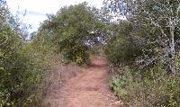
The main trails were well maintained and wide enough so that you wouldn't have to push through grass or brush.
Though small by state park standards, Lockhart State Park includes a number of named trails that snake around the golf course that draws the majority of the park's visitors. We started our hike at the recreation hall at the end of Park Road 10.
Caddy Trail starts south of the recreation hall and heads south, trending downhill back towards the road. The trail here is not terribly well maintained and the going is a bit rocky. The rock on the path though reminded me of the stonework done by the Civilian Conservation Corps for many of its structures so I'm wondering if some of the rocks here are leftovers from the CCC's construction work.
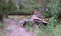
The Clear Fork Creek trail starts by crossing the creek on one of the many CCC era dams that can be seen along the trail.
When the trail crosses the road it turns into the Chisolm Trail and the going gets a bit better. The trail is wider which means less pushing through grass or brush and gathering up some chiggers on the way.
The soil along parts of the trail tends to be slightly sandy, which provides the perfect environment for ant lions. Some sections of the trail almost look like they'd undergone bombardment from a collection of micro meteorites due to all of the small crater-like traps that the ant lions had laid out.
A couple of side trails and loops lead off from Chisolm and Fence-Line Trail once the trail turns left at the park boundary. The side trails are a bit more like the Caddy Trail in that they are more prone to overgrowth.
One of the side trails, Persimmon Trail, is aptly named. It contained a larger collection of very large Persimmon trees than I think we've seen anywhere else. The conditions here must be ideal for their growth.
The CCC Trail leading up to the recreation hall at the top of the hill was overgrown and hadn't seen much maintenance recently. This section was a bit better than most.
The park features a number of markers showing some of the native flora in the triangle of trails in the southeast quadrant of the park. An interpretive guide is available at the park entrance. Though not listed in the guide as a native, we were still surprised to see a few invasive
Chinaberry trees marked on the trail. We thought such an invasive plant would have been cut down in a state park and not highlighted.
At the other terminus of Park Road 10 where Hilltop and Creekview ends Clear Fork Creek begins. It's starting point is a traverse of one of the many CCC era dams that line Clear Fork Creek.
Clear Fork Creek follows the creek towards the northwest and is very overgrown in places. It looks like it hasn't had much attention lately. Once you've come to the end of the trail you'll be dumped off on Park Road 10. One can double back at this point, but the other option is to turn left and walk along the road a bit looking for the last trail on the right.
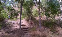
The CCC Trail is a short path leading up the hill towards the recreation hall that was our starting point. This trail was also overgrown and in need of maintenance. It was also in some ways the most interesting in the park due to the stairs, ledges and railings that had been put into place.
All told, we managed to log over 3 miles during the day with not much doubling back. This turned out to be more trail than we were expecting and a bit rougher than we thought it would be.