Getting there: McKinney Roughs is located right on Hwy. 71 between Austin and Bastrop. From Austin, head east on Hwy. 71 past Austin Bergstrom International Airport. Proceed for about 10-15 miles and look for the park's distinctive rock wall
entrance with windmill on the left. Hiker check in is at the LCRA Office near the main parking area.
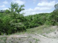
The Hike: The southern portion of McKinney Roughs is heavily populated with interconnecting trails. The outer southern loop hike starts at the spot marked by the "Trailhead" waypoint on the topo map. This spot is behind the red Environmental
Learning Center building. On my visit there was lots of construction going on here as McKinney Roughs goes through a building program to expand upon its educational mission. Carpenters were busy at work on buildings that will be used for dormitories and conference centers.
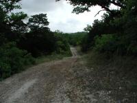
Some portions of the southern loop are old jeep trails.
There is no Southern Loop trail on the McKinney Roughs hiking map. Instead the system of interconnected trails each has its own name, which makes naming a long hike difficult. As the hike turns onto officially named park trails I'll point them out to aid navigation.
To start off head north on the Riverside Trail. Due to construction at the time of my visit the normal starting point was blocked off. Follow the Ridge Trail for a short distance and a cutoff to the Riverside Trail will appear soon thereafter.
When the trail intersects the Pine Ridge Trail turn right and head east. We're attempting to get to Bobcat Ridge Trail which will allow us to finally begin the clockwise loop around the southern half of the park. Pine Ridge is a hiker-only trail so one need not be on the
lookout for horses on the trail. Hiker-only trails tend to be narrower and contain more dense overgrowth, but that's not always the case. When the trail intersects Bobcat Ridge turn to the right and head south west.
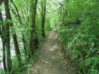
As the trail lowered to the Colorado River the extra moisture fed a thick carpet of greenery.
The trails on my visit had an unfortunate trait that I had not anticipated - cobwebs. Lots of them. Spiders find that by spanning a sticky web across a open area like a trail they can capture more frequent meals. What it meant for me was a frequent brushing of my arms
and legs to free myself from the web's snare. Eventually I adopted a long branch, which when waved in front of my direction like a royal scepter cut down on the number of web collisions. But sometimes the method served only to break the silky stand, which willowed in the wind and stuck to the first available object, often my clothes or skin.
The second phase of the hike begins when it comes into contact with the Colorado River.
Added to the spider webs were catepillar strands. Hanging under oaks like bungee jumpers
the little green guys contributed to making the going slow as I tried my best to clear a
path. I'm sure that fellow hikers who followed my path later in the day reported far fewer
web encounters. Don't let this tidbit scare you. Spring is bound to include more activity with
respect to spider webs. Hiking at different times of the year may avoid this hassle.
The trail will cross the entrance and exit driveways for the park, so please be careful when crossing. On my visit I had to stop at one of the crossings to observe a hummingbird moth darting from one Indian Paintbrush flower to another, getting some food, but also assisting the wildflower in its efforts to create next year's crop.
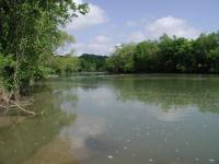
The trail follows along the bank of the river for about a mile.
Flat portions of the hike are often marked by pocket prairies. The spots of open land
are a treasure trove of wildflowers. One of the better areas for wildflowers of all
varieties was the pocket prairie along the trail west of the driveway crossing.
The trail descends into a valley and then turns right onto what the LCRA calls Coyote Road. This wide jeep trail provides plenty of room to allow horses access though I saw none on this hike except along the river. The terrain is rocky and rolling, though
mostly downhill as the trail descends toward the river. Small clumps of wildflowers were distributed here and there along the sides of the road.
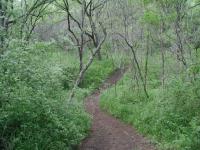
The southern half of McKinney Roughs is more rugged than the northern half and the trail undulates up and down the hillsides.
At the intersection with Riverside Trail turn right and be ready for a complete change of
scenery. All of a sudden the surrounding vegetation closes in. The trail narrows
considerably and the wildflowers disappear. Instead the ground is covered in a thick
carpeting of various grasses, all very green. The trail descends even more abruptly
towards the river, which can finally be seen, and heard, at the waypoint "River View".
At several points along the river rocks build up in sufficient quantity to cause the river to swirl and dance around the obstacles. Though not falls or rapids by anyone's definition the terrain creates water dances that emit a soothing sound.
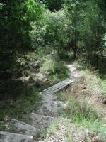
No creek crossing on the trail presents any problems and often includes a bridge, such as this one.
The trail follows the river downstream towards the southeast. Here and there one can find a spot for a better view of the river between the foliage. Perhaps the best spot to view the river is at the waypoint "Rocky Bed". Here a large number of rocks have gathered to provide an opportune promontory from which to view the river up and downstream.
Watch where you step when on any trail. You never know what may be underfoot. Along this section of trail I came upon a lizard sitting right in the middle of trail, motionless and staring up at me. I stared back for a few moments and crouched down for
a better look. He did not budge an inch. Upon hearing some other people nearby I nudged him a little in an effort to encourage him to find safety off the trail. Only then did he scurry off into the leaf litter along the trail.
It was along this stretch of trail that I encountered the only horses I would see during the day. As instructed by the hiking guidelines outlined by the LCRA I stood on the side of the trail motionless and gently chatted with the riders as they went by. As has always been my experience at McKinney Roughs the riders are friendly and considerate.
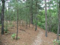
Pine needles litter the path of some of the trail. McKinney Roughs is on the edge of the Lost Pines.
As the Riverside Trail begins to turn south back towards the trailhead my loop continues by turning left at the intersection with the Cypress Trail. This continues to follow the river for another half mile or so before it too turns away and starts uphill to the
south.
Cypress Trail ends at the Pine Ridge Trail. I continued the clockwise progression by turning left at the intersection. The trail plunges back down to cross a small creek and then climbs back up on the other side. At the crest of the ridge on the other side of the creek one discovers that Pine Ridge is aptly named. Groupings of pine trees dot the landscape, sentinels on the outskirts of the Lost Pines forest further east at Bastrop State Park.
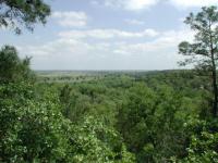
Further uphill there are several magnificent views of the Colorado River below. Note the farmland on the flatter land on the opposite side of the river.
A wonderful view of the Colorado River is available at the waypoint "Overlook". The view shows some of the contrasts in the land here. To the right of the river the hilly terrain continues and is heavily forested. On the opposite bank the land is relatively flat and since it
is more conducive to being farmed it has been cleared. The view behind the vantage point is not a picturesque. This spot was the scene of a large scale prunning effort by trail maintainers. Trees in this area blew down and had to be cleared from the trail. At the time
of my visit some of the cut branches were piled up awaiting transport out of the area.
The McKinney Roughs trail map does not make any mention of ranch ruins along the trail. According to the information center the property was a working ranch having first been settled by John Wise and his family in the 1850's. The Wise family continued to live on
the property up until the 1950's when the family home burned down. The remains of a corral can be seen at the waypoint "Corral" and what may be the location of the Wise home can be found along the trail not too far afterward. All that remains of the home now is a concrete slab and chimney.
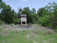
Several ruins can be seen along the trail providing clues to the ranching that used to take place here.
The Pine Ridge portion of the trail snakes its way along the southern edge of a steep creek canyon. Shortly after crossing a small creek on a footbridge a short side trail leads to a small pond near the boundary of the park. Back on the Pine Ridge Trail the
path leads to the intersection with Bobcat Ridge, which I encountered earlier in the hike. Continue straight through the 4-way intersection and follow Pine Ridge back to Riverside and then back to the trailhead.
Economics teaches us that everything has a price associated with it. Nature, though it plays by different rules, shares this characteristic. Acrobatic hummingbird moths, posing lizards and beautiful views sometimes come with a price tag of pushing through cobweb after cobweb on the trail. The question is not whether there's a cost, it's a question of whether the benefits are worth the price to be paid. The answer is definitely yes.