Hamilton Greenbelt

Trail
3.00 Miles
100 Feet
N/A
3point5stars (3.83)14
2stars (2.07)
2stars (2.04)
N/A
Yes
Yes
N/A
Lakeway
Travis
More Info

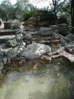
This interesting water fountain sits at the hike trailhead.
Getting there: From west of Austin on Ranch Road 620, head south into the town of Lakeway. Turn right onto Lakeway Boulevard and head west for approximately one mile. Turn right onto Lohman's Crossing Road. Look for the parking area on the right about a quarter mile from the Lohman's Crossing turn.

The Hike: The Hamilton Greenbelt is a surprising hike that provides a wide variety of terrain that is bound to please just about anyone. Depending on how far you venture from the trailhead you'll encounter flat gravel, hilly hard pack or mildly steep rocky sections.

The terrain at the start of the trail is easy enough for hikers of all abilities.
The land that comprises the Hamilton Greenbelt was generously donated by former Lakeway residents Jack and Myrtle Hamilton. In addition they also provided funds for its perpetual care. There is a plaque commemorating their donation at the trailhead. The trailhead also functions as a nice small sitting park complete with benches and a sculpture waterfall.

The trail starts off with a flat, gravel surfaced section that passes under stately oaks and various other species of tree. Some of the trees have identification markers on boulders nearby, but many of the markers appear to have gone missing over the years.

One of the more interesting features to be found along the hike.  This circular waterfall provides a pleasant spot at which to stop for a break.
One of the more interesting features to be found along the hike. This circular waterfall provides a pleasant spot at which to stop for a break.
This greenbelt features an interesting circular waterfall at the waypoint "Waterfall". Here you'll find plenty of ferns clinging to slick rock overhangs. This waterfall is so interesting, in fact, that it's a shame that it was not made the centerpiece of a park. Instead, the backyards of houses line the opposite bank of the creek.

Many majestic oaks line the trail.
After the waterfall the trail becomes ever so slightly more difficult. Parts of the trail are covered in mulch and the trail begins to rise above Hurst Creek. The real change in terrain however happens at the waypoint "Primitive Trail", which is actually the name of the section given by the trail maintainers. Though not technically challenging, the trail takes on a much rougher nature than the more park-like trail that lead up to this point.

The primitive trail climbs up the slope of a ridge and splits into two at the waypoint "T-Left". By going left you'll be rewarded with some of the roughest portions of the hike and great views of Hurst Creek as it empties into the lake. The right fork leads to the alternate trailhead that we'll encounter later.
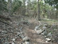
The farther one gets from the trailhead the rougher the hiking gets.
After hugging the slope for some distance, the trail descends to water level and slices through a meadow of Cedar Elm trees at the waypoint "Hurst Hollow". Beyond the waypoint, near the turnback point, there is a large stone picnic table with great views of the Hurst Creek arm of Lake Travis.

On the back loop the trail ascends the slope over the lake once more before descending again back down to Hurst Hollow. On the return path you have an option of either retracing your steps back to the trailhead or exploring the trails to the alternate trailhead mentioned previously. To visit the alternate trailhead, veer to the left on the parallel path at the "CrossOver" waypoint.

In all, we logged approximately three miles. This entertaining hike provided a wide variety of terrain and sights right in the middle of a fast growing area of the Hillcountry and is highly recommended.

Photos
Trail map
Trail map at entrance. (Photo by Eveline)
Rock Wall
This spot along Hurst Creek provides a turnaround point for those who do not want to hike the primitive trail. (Photo by Austin Explorer)
Primitive Trail
The "primitive trail" portion of the hike provides the best views and most challenging terrain. (Photo by Austin Explorer)
Unnatural Feature
The natural sights along the trail are not the only interesting things to be found. (Photo by Austin Explorer)
Trail View
The primitive trail cuts through a boulder field. (Photo by Austin Explorer)
Hurst Hollow
Hurst Hollow along the shore of a Lake Travis arm resides near the farthest point from the trailhead. (Photo by Austin Explorer)
Lake Travis
The return loop rises above the trail hiked below and provides numerous views of Lake Travis. (Photo by Austin Explorer)
Log Entries
Lovey hike in Lakeway
By DanaL on 2/6/2016
Rating: 5stars Difficulty: 2stars Solitude: 3stars
Distance: 4.09 Miles Duration: N/A

Hidden gem in Lakeway.  Lovely large granite trail at the beginning, and the primitive trails further in are just beautiful.  Some marginally challenging terrain, but nothing lasts very long.  Goregous views from some of the rest benches.  I can do this hike over and over and enjoy it every time.  Can get kind of crowded though. 

Nice area with some rough terrain
By Eveline on 5/10/2014
Rating: 3stars Difficulty: 1star Solitude: 1point5stars
Distance: 3.00 Miles Duration: N/A

We walked this as part of a 10K volksmarching event.

Beautiful Hike w/ Interesting Sites
By mgialusis on 3/24/2012
Rating: 3point5stars Difficulty: 1point5stars Solitude: 2stars
Distance: 2.00 Miles Duration: N/A
Great!
By texaskdog on 4/10/2010
Rating: 4stars Difficulty: 3stars Solitude: 3stars
Distance: 5.00 Miles Duration: 2 hours

Turned out to be a great hike!  Little doubling back (you can head back to the main trail from the alternate path w/o doubling back).  Short side trail named Smith Greenbelt that will take you 10 minutes round trip that is worth checking out too (it is on your left just after you enter the main trail by the small garden).  Worth the drive to Lakeway for.

By Melissa-Austin on 3/10/2009
Rating: 3stars Difficulty: 1star Solitude: 1star
Distance: 3.00 Miles Duration: 1 hour

Crushed granite trail runs along a creek & cliff - very nice.  Lots of trees & great sitting areas, but you can see big beautiful houses at parts of the trail.  There is also some white sprinkler piping running along much of the trail which takes away from the natural beauty.  There are a couple water fountains along the way.  Part of the trail, I veared to the right & hiked along a little more rugged trail - it was absolutely beautiful, but it dead-ended & I had to take the regular trail most of the way.

Unknown Hike in Lakeway
By bspross on 11/2/2008
Rating: 5stars Difficulty: 2stars Solitude: 3stars
Distance: 5.25 Miles Duration: 2 minutes

I had no idea this hike was right in the middle of Lakeway.  It takes you all the way to Lake Travis.  There are a lot of loops so it is not a lot of doubling back on yourself which I love.  This is a great hike right in town.  The solitude was nice and we did not hear much traffic or neighborhood noises.

Nice hike, good variety of terrain
By sjs on 10/14/2008
Rating: 4stars Difficulty: 2point5stars Solitude: 3stars
Distance: 3.00 Miles Duration: N/A
By lancescape on 12/27/2006
Rating: 4stars Difficulty: 3stars Solitude: 2point5stars
Distance: 4.00 Miles Duration: N/A
Caching and Hiking
By Austin Explorer on 6/20/2004
Rating: 3stars Difficulty: 2point5stars Solitude: 2point5stars
Distance: 2.70 Miles Duration: N/A
Revisited the greenbelt to find three geocaches that are hidden along the trail. Found a new side trail that I didn't know about before, which I'll add to the hike topo map shortly.
Nice hike
By Blizzard on 12/27/2003
Rating: N/A Difficulty: halfstar Solitude: halfstar
Distance: 2.00 Miles Duration: N/A
some runers and walkers

Only showing last 10 log entries. View All Log Entries

Recommended Item
Recommended Item 60 Hikes Within 60 Miles: San Antonio and Austin: Including the Hill Country
Charlie Llewellin, Johnny Molloy
List Price: $18.95 Your price: $11.96 Buy Now
It's Time to Take a Hike in San Antonio!

The San Antonio and Austin areas are steeped in history -- San Antonio's Alamo stands as a symbol of Texas' fierce independence, while Austin is recognized as the cradle of Texas statehood. This area is also known for some of the most impressive hiking in the Lone Star State. 60 Hikes Within 60 Miles: San Antonio and Austin, by veteran authors Charlie Llewellin and Johnny Molloy, guides readers to the best trails found in the Texas Hill Country, all within easy reach of these two cities. The guide takes you to secluded, low traffic areas as well as those that are more popular and heavily used. The former LBJ Ranch, the Guadalupe River, the Highland Lakes Chain, and the Lost Pines area are just some of the spectacular places covered.

With this new edition in the best-selling 60 Hikes Within 60 Miles series, all these visually stunning and ruggedly charming routes are at the traveler's fingertips. This handy guide helps San Antonio and Austin natives get back into nature, with many options right in town. Extensive at-a-glance information makes it easy to choose the perfect hike based on length, difficulty, scenery, or on a specific factor such as hikes good for families, runners, or birding. Each trail profile includes maps, directions, driving times, nearby attractions, and other pertinent details.