Chalk Ridge Falls Park

Trail
5.00 Miles
N/A
N/A
3point5stars (3.68)36
2point5stars (2.57)
3stars (3.25)
Yes
No
No
N/A
Belton
Bell
More Info

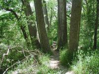
The first portion of the trail is paved, but some rougher stuff lay ahead.
Getting there: Exit from I-35 and head west on FM 2484 for about one mile. Turn right onto FM 1670 and head north for 3.5 miles. Look for the park entrance on the right. Proceed down the winding driveway to the parking area near the trailhead.

The Hike: The trails at Chalk Ridge present something of a mystery. At the trailhead, marked on the map by a waypoint of the same name, one finds an interpretive sign pointing out some of the animals one might find on the hike, but no trail map. So I set about mapping as much of the trail as I could in the time I had. Little did I realize that I would map a bit more than planned.

A winding boardwalk conveys the trail across a wide creek bed near the start of the hike.
The trail starts off along a straight berm overlooking the Lampasas River to the left. The gravel surface here through the falls provides a very easy hike for those who are looking for a simple stroll. At perhaps a quarter mile into the hike a large wooden bridge provides a passage over a stream bed that empties into the river. Just over a small ridge lies the crown jewel of the park, the falls from which the park derives its name.

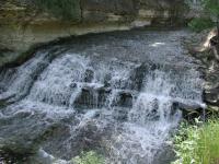
Chalk Ridge Falls, the feature that gives its name to the park that surrounds it.
What Chalk Ridge Falls lacks in size it makes up for in small details that made me want to sit and watch the water for some time. The water's descent follows a gentle, eliptical curve, vertical or rocky uneven crashes. But the chalk rock formations provide just enough of an uneven texture to the curve to cause the water to dance as it smoothly arches its way downward. A slab of harder rock in the middle of the falls proved to be more resistent to the water's will and so several pieces jut out defiantly into the torrent. Under the protective shield of the rock, ferns have taken hold and found an ideal place for themselves.

The cable suspension bridge provides a safe, but wavy trip across the water downstream from the falls.
The trail system at Chalk Ridge Falls is identified by wooden trail markers painted with different colors. The red markers are easily identifiable, but I'm unsure as to whether there are separate blue and green markers, or if they are one and the same. Turning left at the falls, a split in the trail goes left yet again for a quick turn back to the trailhead (blue/green marker) or to the right for an adventure of a different sort (red marker).

The red trail option ventures downstream from the falls and then crosses the creek on a steel cable suspension bridge. If you're easily sickened by the rocking of a boat on the water you'll want to pass over the span alone, or else your companions may compare the shade of color on your face with lunch's guacamole.

Erosion control mechanisms, such as this staircase, should not be avoided.
On the opposite bank the red trail turns to the left and begins its long journey following the Lampasas River downstream. A side trail forks away temporarily to pass closer to the ridge line to the right. In one spot the rock forms a small overhang that people seem drawn to, judging from the well-worn path leading up to it.

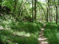
While the trail leading up to this point was wide and terribly easy, things get slightly more rough on this side of the park. The terrain is gentle, since it follows the contour of the river, but the trail itself is hemmed in on both sides by abundant grasses and bushes. Poison Ivy was present, but not too common earlier in this hike, but constantly brushing up against vegetation causes one to concentrate on what's coming up under foot to avoid any contact with it.

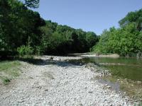
The trail provides a number of opportunities to get into the river.
Along the trail red markers pointed the way to the northeast. At the waypoint "Last Marker" I encountered what I believe to be the final marker on the trail. It had an arrow that pointed straight ahead, so I marched onward.

On the one hand, I had a suspicion that the trail should be ending soon. On the other hand I had a well worn, clearly visible trail in front of me with no signs or barriers telling me to stop. Tiring of the high grass, I thought of turning around. However, I also did not want to miss the end of the trail, which I imagined to be just around the next bend.

The red trail across the suspension bridge is more overgrown.
I was rewarded for my efforts by the second waterfall of the hike. Not nearly as picturesque as Chalk Ridge Falls, this small waterfall nevertheless provided a nice spot to stop for a snack. Still I continued on along the river bank until I ran into a boundary of sorts, the dreaded Poison Ivy. Whereas before an occasional plant would cause me to hug this or that side of the trail the Ivy now provided no passage, all the while the trail continued into the distance. What lies beyond would have to wait another day.

The red trail provides heavy tree cover, but also heavy grass coverage of the trail.  Often the trail was even more overgrown that shown here.
The red trail provides heavy tree cover, but also heavy grass coverage of the trail. Often the trail was even more overgrown that shown here.
It was not until after I got home and plotted out my track did I observe that a portion of my hike was probably on the edge of the Camp Tahuaya Boy Scout facility. Had the Poison Ivy not turned me back I might have found myself reciting the Scouting Pledge. Even on the return trip, I could not spy a sign indicating the proper edge of the park, so if you want to be absolutely safe, venture out just east of the last marker waypoint, or no further than the second waterfall.

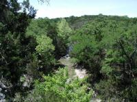
From a bluff overlooking the stream that soon feeds Chalk Ridge Falls.
As you can see from the map, I did not even begin to explore any possible trails on the northern portion of the park. In all, the 4 miles I hiked out and back did not equal the reported 5 miles the park contains, so there is more to be discovered out there.

According to reports, the ADA (wheelchair) accessible parts of the trails include the Old River Road Trail (goes along the dam to boy scout camp) and partially accessible sections include the trail to the falls.

Important: Thanks to some useful info from other hikers, it has been made known to us that this park occasionally closes following dam discharges following heavy rains. These can take place weeks after heavy rains. The official website does not always post these closings, so it may be a good idea to call ahead before making the trip out there.

Photos
huge
the trees are huge (Photo by jimmy peace)
canopy
its like being in a jungle (Photo by jimmy peace)
trash
it is sooo sad that others trash our trails (Photo by jimmy peace)
swing bridge
the swing bridge (Photo by jimmy peace)
the falls
water still running (Photo by jimmy peace)
Water Falls
The main attraction at this park is the waterfalls that the kids love. (Photo by Branden)
Bridge
Here is the bridge that is washed out. (Photo by Branden)
Trail Closed
This is the trail head for the bridge that is washed out. (Photo by Branden)
Washed out bridge
The trail only goes 20 feet more to the left of where this photo was taken. Then the trail is blocked off and there is a collapsed bridge. If you cross the dry stream bed in another 50 feet you will come to this washed-out bridge. (Photo by BrownMJ127)
Trailhead
The Chalk Ridge Falls trailhead. An interpretive sign is under the tree on the righthand side of the trail. (Photo by Austin Explorer)
Chalk Ridge Falls
Another view of the falls, this time head on. (Photo by Austin Explorer)
Bridge closeup
A closeup of the suspension bridge. (Photo by Austin Explorer)

Only showing last 12 photos. View All Photos

Log Entries
no cave
By jimmy peace on 6/24/2013
Rating: 4stars Difficulty: 3stars Solitude: 4stars
Distance: 4.00 Miles Duration: N/A
still havnt found the cave yet, and hiked further in.. but now we think we know where it is
By Kat Person on 12/31/2012
Rating: 4point5stars Difficulty: 2point5stars Solitude: 2point5stars
Distance: 5.00 Miles Duration: N/A
Variable hike of solitude and wilderness
By Kat Person on 12/8/2012
Rating: 3point5stars Difficulty: 2stars Solitude: 4stars
Distance: 5.00 Miles Duration: 4 hours

When you enter, there are lots of people fishing and hanging out in this park.  As you go further back into the park, you will slowly drop away from people and see more and more of the wild.  The trail eventually becomes less marked and you will have to pick your way through a lot of brush in places.  There is a trail and you can find it but you have to be adventurous.  The cave is a real high point if you can find your way.  There is a high road and a low road in the beginning.  The tempation is to follow close to the water but take the high point either going in or coming out to gain a beautiful experience with light as it falls through tall trees.  Lots of butterflies in this park and some trees appear to be oozing some nectar because the butterflies were clinging to the trunks of several.  I come here all the time and it is a magical place.

Nice but short
By 9hiking on 3/18/2012
Rating: 2point5stars Difficulty: 2stars Solitude: 3stars
Distance: 2.00 Miles Duration: N/A
Kids enjoyed it. we had children ranging from 6 to 15 and they all were able to hike the trail with ease. The bridge and water fall was fun for them. Park info shows 5 miles, but it was only 1 mile in and 1 mile back out...unless there are other trails that we missed...
My first local hike. It was a simple introduction, crisp, sunny and peaceful.
By Amuzed on 12/17/2011
Rating: 1star Difficulty: 1star Solitude: 4point5stars
Distance: 4.00 Miles Duration: 5 hours

 The Falls were a trickle, at best. The trail however was nice. I explored the red blaze trail, to what became bushwhacking for about a mile when I decided to turn back.

The river is nice. The woodlands were fun. The boulders were a great place to lunch.

I plan to return and follow the blue/green blaze.

How far will folks carry beer bottles into the woods? This was the only negative of the day.

Fun walk. Take the kids.
By pjberonio on 10/31/2010
Rating: 3point5stars Difficulty: 2stars Solitude: 2point5stars
Distance: 2.00 Miles Duration: N/A

Great, easy walk for the kids.  Had a blast!  Bridges washed out though.  I really hope they fix them at some point.  Still a beautiful place.

Great short hike with kids
By bugsparrow on 9/4/2010
Rating: 3stars Difficulty: 2point5stars Solitude: 4stars
Distance: 4.00 Miles Duration: N/A

Went out this morning to visit and hike the trails at Chalk Ridge. We took both of our kids ages 7 and 11 and they had a blast. Just enough terrain differences to keep them from getting bored and plenty of dragonflies and minnows to find. Both bridges are still terribly washed out, however we were able to cross alongside of the wooden foot bridge with out getting wet. Great little nook just along the waterside at the top of the falls to stop for a break and eat some lunch. The trail markings are inconsistent and there are alot of worn paths that veer off the trail, but if you stay near the water you'll have no problem finding the bridges or the falls. There is lots of trash scattered about, and if you want to get in the water, watch for hidden glass...

Nice morning hike
By athena_ginny on 8/29/2010
Rating: 3point5stars Difficulty: 2point5stars Solitude: 3stars
Distance: 4.00 Miles Duration: N/A

My husband, 8 yr old and 13 yr old along with myself took this hike Sunday morning. Pretty easy path to follow until you get to the bridges. Two of the main bridges that lead to the "caves" are out so we had to find another way to cross the river. If you don't mind getting a little wet plenty of places to do that (lots of places that are only ankle high deep in water). LOTS of litter though. Easy hike for smaller kids though we got off the beaten path and a few high slippery trails to cross my 8 yr old did great.

By Miles on 5/16/2010
Rating: 4stars Difficulty: 4stars Solitude: 5stars
Distance: 2.85 Miles Duration: N/A

Geocaching off trail. High grass made it hard walking.

Not very accessible.
By texaskdog on 2/28/2010
Rating: 3stars Difficulty: 4stars Solitude: 4stars
Distance: 7.00 Miles Duration: 2 hours

First of all the best part.  When you get to the long bridge, go down the stairs and walk upstream.  Not really a path but the water is never deep.  Beautiful canyon with numerous caves with water running through.  This part takes about a half hour.  After that we took the main path.  The suspension bridge broke over 2 years ago and they havent fixed it and people still work their way across it, very dangerous!  We crossed in the creek.  The path beyond it is overgrown and brushy and not very exciting.  We never made it to the waterfall but must have been close.

Only showing last 10 log entries. View All Log Entries

Recommended Item
Recommended Item Hiking Texas: A Guide to the State's Greatest Hiking Adventures (State Hiking Guides Series)
Laurence Parent
List Price: $24.95 Your price: $21.10 Buy Now
From the rugged Guadalupe Mountains in the west and the deep canyons of the Red River in the Panhandle to the lakes on the eastern landscape, the Texas backcountry is as spacious and diverse as the Lone Star State itself. This guide contains unforgettable hikes that suit all abilities and interests.