-small.jpg)
Blunn Creek Greenbelt is a popular spot for walks through the neighborhood.
From central Austin, exit I-35 onto Riverside Drive and head
west. Turn left onto Alameda Drive and head south taking the next available right to get to
Little Stacy Park. Park along the road near the park sign.
The Hike: The Blunn Creek Greenbelt is a short, urban stroll through South Austin's
Travis Heights neighborhood. The trail actually connects two separate parks, as far as the city
of Austin is concerned, Little Stacy Park to the north and Big Stacy Park to the south. Further
confusing matters is that Little Stacy Park is bigger than Big Stacy Park.
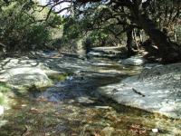
Blunn Creek features fairly clear waters, a surprise given the city around it.
The trail begins at the waypoint marked "Trailhead". There is ample parking here, along with
restroom facilities, basketball court, volleyball area and a playscape. The trail really does
not start in earnest until it crosses Blunn Creek on the East Side Drive bridge. Once on the
opposite bank the trail is easily visible on the left.
One expects a more urban trail to be fairly easy to hike and that is the case here. The trail
surface is a mixture of paved concrete and crushed granite. The trail is a favorite path for
neighborhood residents to walk or bike for a bit of exercise. On our trip we were rarely out of
view from someone else on the trail, though it does not attract crowds like the more popular
Town Lake trail nearby.
-small.jpg)
Blunn Creek Greenbelt is a popular spot for walks through the neighborhood.
Keep an eye open for metal markers placed in front of trees along the trail. Each includes a
number marking an interpretive guide station. Some, but not all, markers also include the tree's
name etched on its surface. What's the difference between an Elm and a Cedar Elm? You can try
and find out since an example of each is within a short distance from each other.
We'll try and find a key to the markers and provide them here in the future.
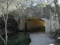
The trail doesn't just go over bridges. It also passes under one.
In addition to the sampling of nature, there are some interesting man-made sights along the trail
as well. The trail passes under one old bridge and later over another that reminds me of a
Frank Lloyd Wright design. It will be hard to miss one of Austin's famous Moon Towers that
resides on East Side Drive at Leland Street.
The trail comes to an end at the waypoint "Turnaround" next to Travis Heights Elementary.
There is a parking area here for those searching for an alternate trailhead, though parking is
more at a premium here due to the nearby public pool. The "Frank Lloyd Wright" bridge is nearby
and what appears to be a small seating area along the creek that has seen better days.
We ventured out and back in one and a half hours, covering 1.5 miles. It was easy to slow down
the hiking pace to match the residents' stroll as we tried to identify trees and noticed some
unique architectural features of the houses that line East Side Drive.