[ Log In ] or [ Register ]
Austin Explorer

Comanche Bluff Trail

Trail (3.69)
(2.90) (4.06)
7.50 Miles 650 Feet
N/A No
Yes Yes
Free More Info
Granger Williamson
Take Action Bookmark and Share

Getting there: From I-35 in central Round Rock take the Highway 79 exit and head east towards Taylor. Once in Taylor turn left onto Highway 95 and head north. Near the community of Circleville turn right onto FM 1331 and look for the park entrance on the left in about 4.5 miles.

The Hike: Granger Lake is one of the lesser known recreational areas around Austin. Situated in the rolling terrain of northeast Williamson County on the Blackland Prairie, it offers some interesting sites and good solitude away from the RV camping areas. An added bonus is that there is no charge for park admission for day hikers.

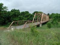
The Hoxie Bridge is one of the old Williamson County bridges salvaged from the scrap yard for the trail.
The hike begins at the waypoint "Trailhead" at a parking area that includes a restroom. Printed trail maps are available here and at a couple of other stops along the trail.

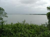
A view of Granger Lake from the trail.
The first section of the trail alternates between wooden sections and small pocket prairies. The trail skirts around a bluff on which RV camping takes place. In the first mile of the hike, the campers can occassionally be seen and are usually heard along the trail. One of the better views of Granger Lake can be found along this first section of trail, however.

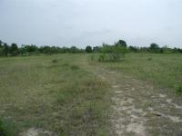
The trail consists of a mix of wooded segments and open prairie.
The highlights of the first mile are the bridges. Granger Lake and the parks around it are administered by the U.S. Army Corps of Engineers. So one would expect them to know how to build a good bridge. Rather than settle on a small wooden span across two creeks they chose to over-engineer and save a little bit of history at the same time.

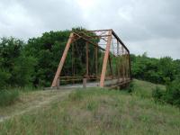
The Friendship Bridge.
The Hoxie Bridge can be found perhaps a quarter mile from the trailhead. It originally spanned the San Gabriel River, but was washed downstream in a flood in 1921. It was reconstructed and remained in use until 1979. Rather than send the outdated bridge to the scrap yard it was moved to Granger Lake in 1982.

A few portions of the trail are a little challenging. Here I had to crouch to get under the brush in a creek bed.
The Friendship Bridge can be found at the waypoint of the same name about 1 mile into the hike. Like the Hoxie Bridge this one was destroyed by a flood in 1921, likely the same flood as the one that destroyed the Hoxie Bridge, and reconstructed. It too was moved to Granger Lake by the Corps of Engineers in 1982. These two bridges make for fine, if not overbearing, crossing of two of the trail's streams.

Not all of the bridges on the trail are historic or overkill.
The relatively flat, rolling terrain of the area surrounding Granger Lake is somewhat misleading. The lake's south shore hugs a modest ridge by hillcountry standards, but it provides a bit more of a challenge than the drive in would indicate. This becomes particularly evident as the trail proceeds west from an alternative trailhead at the waypoint "Alt TH". Not only does the vegetation close in on the trail, but the going gets tougher as the path descends into small, but steep, creek beds. On a few occassions I was not entirely certain if I was still on the approved trail and not some maverick trail.

A view of the lake along the trail before plunging into the woods again.
Following the ups and downs of the creek crossings, the trail flattens out a bit, but a new obstacle presents itself in the form of cow patties, and lots of them. It's like tip-toeing through a minefield, though without the danger. Still, by all means, watch your step.

This carpet of driftwood provides an obstacle along the trail.
Just when the worst seemed over, a more daunting challenge emerges. High water at some time in the past deposited a large amount of driftwood near the lake shore, smack dab in the middle of trail. When I say a large amount, I don't mean a few hundred limbs scattered abount, perhaps in a contour line marking the old water line. No, I mean thousands of branches and trunks that litter the ground like poorly constructed wooden planking. There is no stepping around them, there is only walking on them, and trying very hard not to twist an ankle in the process. One might think about turning back, but that would be a mistake.

After the trials and tribulations, a serene segment in a glade.
Things change dramatically at the waypoint "Gate". A fence has kept the cows out and so the cow patties almost disappear. A gentle glen of trees marks one of the quietest spots I found along the hike. A short distance to the west the tree cover recedes and some open prairie leads to a small inlet of the lake marked by the waypoint "Lagoon". Where I found two boys fishing who seemed to think it odd that I had walked about 3 miles at that point, with more to follow.

One of the larger pocket prairie segments along the trail.
The trail west of the lagoon occassionally splits off from the jeep trail into which it transforms. However, it may be a good idea to stick to the jeep trail, particularly when poison ivy is out. While the trail was mowed to keep the weeds at bay, the trail surface showed how prevalent poison ivy is in the part of the trail. Walking on poison ivy stems is as bad as brushing against them if you happen to touch the soles of your shoe for some reason.

A few segments of the western end of the hike follows a jeep trail.
The end of my hike is marked by the waypoint "Turnaround". However, it may not be the end of the trail, depending upon your view. The jeep trail continues to south from the turnaround point, but from this point it appears to be a service road for the primitive camping area that can be found here. There was not another soul in sight as I stopped in this well maintained camping area to have a snack and drink of water. The facilities include tent sites, picnic tables and a chemical toilet.

The San Gabriel River before it empties into the lake. The primitive camping area here was deserted.
As I sat on a dead log right along the San Gabriel River just before it feeds into the lake, I noticed some ants hard at work. Three large ants were busy excavating a depression in the log, making a home for themselves. Two of the ants would pick up bits of wood and crawl to the end of the log and drop the chip off the side. The third ant below picked up chips from the pile and moved them farther away from the log. On and on they went, in tireless toil. Who am I to complain about driftwood and cow patties on the trail?

Doubling back to the trailhead I ended up hiking 7.5 miles, quite a bit more than I was expecting, but well worth it. On the way back I used the alternate southern loop marked on the map in blue around the southern edge of the RV camping area. I would generally not recommend this route since it cuts right through a busy section of the camping area complete with lots of people, vehicles, boom boxes and the like.

Photos

Red Berries On The Trail This is a shot I took along the trail.Notice the hiking trail in the lower right hand corner. (Photo by Miles) Indian Paintbrush Indian Paintbrush (Photo by IAHiker) Site 21 Lake View This is where we started our hike to Fox Bottom Primitive Campground, and then returned. (Photo by Miles)
A Lake View From Site 21 At Dusk Ah, Spring Break! (Photo by Miles) Fox Bottom Sign If you make the hike, and camp here, this is what you need to know. (Photo by Miles) The Fire Ring at Fox Bottom Oh, The Smell Campfire Smoke! (Photo by Miles)
Camp site at Fox Bottom Primitive Campground. No lights, No Water. You'll have to bring your own! (Photo by Miles) Comanche Bluff trail (Photo by Miles) Comanche Bluff trail (Photo by Miles)
Comanche Bluff Trail (Photo by Miles) Comanche Bluff Trail (Photo by Miles) Comanche Bluff Trail (Photo by Miles)
Comanche Bluff Trail (Photo by Miles)

Log Entries

User: cmbarrick - 5/31/2010  [View Log Page]
Rating: Difficulty: Solitude:
Distance: 2.00 Miles Duration: N/A
Nice trail
User: c1seachelle_and_dogs - 5/8/2010  [View Log Page]
Rating: Difficulty: Solitude:
Distance: 2.50 Miles Duration: N/A
Went with family and dogs. We loved it. Narrow trail that is over grown, but that's nature. Saw only one person for 2.5 miles. Could see campsite at one bridge.
One of my favorites!
User: texaskdog - 1/10/2010  [View Log Page]
Rating: Difficulty: Solitude:
Distance: 5.00 Miles Duration: 1 hour, 40 minutes

Went in January, saw 2 groups of people in 2 hours.  Great variety, the bridges are cool, you are close to the water.  Didn't make it all the way to the end.  If you come from the east, when you get to the gate and driveway you have to go across and reenter the other gate to keep going.  This is a cant-miss!  Drive over the dam afterward.

User: Daniel N - 11/7/2009  [View Log Page]
Rating: Difficulty: Solitude:
Distance: 4.00 Miles Duration: 1 hour, 45 minutes
Fox Bottom Primitive Campground
User: narpigeon - 9/5/2009  [View Log Page]
Rating: Difficulty: Solitude:
Distance: 3.00 Miles Duration: N/A

I thought the trail was perfect, difficult to follow and required quite a bit of back tracking. Due to this I believe most would not return. That is exactly why I am going again. The trees are in poor shape because of the lack of moisture. There was a lot of cows towards the campground. I heard a group of coyotes during the evening. The campground is well maintained and has a nice toilet. There needs to be peat moss available to compost. There is also a nice smoker grill. I made a map of the path I took to find the campground and it is available here.

User: johnbivona - 2/22/2009  [View Log Page]
Rating: Difficulty: Solitude:
Distance: 7.50 Miles Duration: 4 hours, 15 minutes

This is a nice half-day hike with medium difficulty.  The trail is not well marked, especially during the last mile near the primitive camping area.  Stay on the beaten path and you should eventually get to the campsite.  I was amazed at the amount of drift wood and plastic trash that has accumulated around the trail area during periods of high lake levels.  Be on the lookout for deer and hogs as you approach the last 1/3 of the hike!

good thing I like bridges...
User: hikingfreak - 12/7/2008  [View Log Page]
Rating: Difficulty: Solitude:
Distance: 9.00 Miles Duration: 4 hours, 30 minutes

I wasn't sure if I hiked the entire trail but it was a great hike either way.  I did get to the area with the birdhouses, and walked at least  a mile and a half past that on the jeep trail until the high reeds were surrounding me.  I saw a deer on the way out and 5 armadillos and 2 hikers on the way back.  The solitude was wonderful.  I didn't have to pay a fee to get in Taylor Park, but that might only have been because the gate was up and no attendant was on duty today.

Poorly maintained but pleasant
User: raediant - 10/25/2008  [View Log Page]
Rating: Difficulty: Solitude:
Distance: 8.00 Miles Duration: N/A

The trail was hard to follow at points, especially with so much leaf fall. I followed the car tracks beyond the trail turnaround for about 3/4 mile and found myself at a lake inlet dotted with birdhouses. Litter was all too common along the driftwood sites. Other than that, the hike was extremely enjoyable. If you enjoy photographing wildlife, bring a camera and be ready - I spotted at least six armadillos, a black snake, a few lizards, a hawk, a blue heron, and various smaller birds. The high degree of solitude was refreshing and occasional unobscured views of Lake Granger were lovely. I recommend the trail to hikers that enjoy a raw trail full of surprises.

This trail needs work
User: ANDYROOSKY - 10/28/2007  [View Log Page]
Rating: Difficulty: Solitude:
Distance: 3.00 Miles Duration: 4 hours, 30 minutes

This was a fun trail until you cross the first big bridge.  I went immediately right and the trail died out real fast.  So I went back to the bridge and then the trail took me into a camping area...after walking around for a while I found a small little nice trail that went alongside of the trail however it soon died out also.....I found a little playground that my child on and then we did the trail again....I was kinda disappointed...I think I will stay left of the camping grounds next time and I might pick up the rest of the trail....I only rating the difficulty so high because it was so hard to find the trail....no maps or anything...... 

Not the right time to hike this one
User: kstahnke - 6/24/2007  [View Log Page]
Rating: Difficulty: Solitude:
Distance: 3.20 Miles Duration: N/A
I've hiked this trail before but it has been a while. Right now, the trails are overgrown with poison ivy and trees have fallen over several spots requiring some cutting off trail. This can be a fun little hike, but I definitely didn't pick the right time to take it this time. I cut the hike short when I hit the western trail head and the trail followed a fence line and the trail was hemmed in with honeysuckle and poison ivy. At that point, I turned back because I'm quite allergic. I'm not dogging the trail, just advising anyone else thinking of heading out right now.

Only showing last 10 log entries. View All Log Entries

Recommended Item

Recommended Item Hill Country (Hill Country (Lone Star Guides))
by Richard Zelade
List Price: $17.95 Our price: $10.58 Buy Now
This book features ten tours to Central Texas that capture the essence of its flavor and charm. Take a ride on the Fredericksburg & Northern Railroad, follow the historic Mormon trails from Travis Peak Community to Medina Lake, visit Enchanted Rock, explore the Balcones Fault, and much much more.