Southeast Metropolitan Park

Trail (3.93)
(3.17) (4.04)
5.00 Miles 770 Feet
Yes No
Yes No
Free More Info
Del Valle Travis
Loading...
Larger Map
The nature trails at Southeast Metro Park are probably the best in eastern Travis County. (Click on map for larger view)
Maptech® USGS Topographic Series™, ©Maptech®, Inc. 603-433-8500, www.maptech.com/topo Copyright 2000 Maptech, Inc.

Getting there: From IH-35 in Austin head east on Highway 71. Go past Austin Bergstrom International Airport and look for park on the left in about two of miles. There are signs along Hwy 71. When entering the park following the signs indicating a hiking trail by veering to the right and following the road all the way back to the trailhead.

The Hike: Southeast Metro Park is one of the newer parks in the Austin area. Maintained by Travis County it boasts a large number of playing fields soccer and baseball. I had heard good things about the trails here for some time, but when I arrived I wasn't sure how long they were or what type of trail it was.

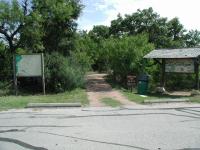
The trailhead has ample parking and a fantastic map of the trails.
The trail starts on the topo map at the waypoint "Trailhead". There is ample parking here and a very good map showing the trails and points of interest along them. The trail heads northeast and follows the backbone of a ridge that becomes more pronounced. At the waypoint "Overlook" there is a nice sitting area with some unexpected views of downtown Austin. This portion of the park resides on a ridge that overlooks Onion Creek and as it turns out, the center of the city.

Numerous dry stream bed crossings dot the trail, but they are easily forded because of the bridges like this one.
Soon after the overlook the trail forks. I ended up going in a clockwise direction and so turned right. The trail descends into and ascends out of the canyon between two ridges then heads north. The trail surface here is mostly packed dirt with some rock. The trail surface was very well maintained and easy to navigate, even in the steeper sections.

The trail descends almost to the level of Onion Creek, though it's never visible. Two ponds dot the path, each with a fishing pier or platform. The second pier is covered and of recent construction. Then it's time to get back up to the ridge top and this involves some of the steeper sections of the hike. A set of log enforced stairs help control erosion of the slopes.

Rabbits, such as this one, were just about the only mammals encountered on the trail. And there were lots of them.
Once on top of the ridge, I came to a side trail that was reported to have led to a primitive camping area. That side trail is represented by the blue track on the topo map leading to the waypoint "Camping Area". My comments about the fantastic nature of the trail maintenance does not apply to this side trail. It was severely overgrown and seemed to peter out completely without an obvious end to the trail. I spent a bit of time deburring myself when I got back to the main trail.

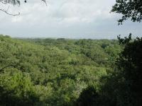
A view along the trail, facing towards downtown Austin in the distance. Visibility was not ideal on this particular day.
Back on the main trail, the path leads south and at the waypoint "View" there is yet another glimpse of downtown. This may be the better of the two views highlighted in the hike, but it's farther away from the trailhead and so does not have as nice a viewing platform.

The trail descends a bit, but then follows the contour of the slope for much of the way back to the fork near the view overlook. From there it's a quick walk back to the trailhead.

A daytime sighting of a racoon along the trail was an unexpected treat.
Encountering a confused racoon along the trail in broad daylight was a surprise. He ended up deciding that the tree he was in was not high enough for his taste and he bounded to the ground and into the brush away from the trail as quickly as possible. What they lacked in antics, the rabbits made up for in numbers. I think I must have spotted close to 10-12 rabbits on this hike, more than I can recall seeing on any other.

Several small lakes lie within the park and the nature trail hits each. This one includes a covered fishing pier.
The main trail loop (minus the camping side trail) is a bit over 2 miles. But there's a bit more to explore. Just a short distance from the trailhead another side trail juts to the west that the park refers to as the Wildlife Trail. This one leads to the waypoint "Blind" on the topo map. The Wildlife Ttrail is not as well maintained as the main trail, but it is nevertheless in better shape than the camping area spur. It descends down the ridge, again almost to Onion Creek level, to a small pond. A blind sits on the edge of the water giving wildlife observers an opportunity to see and not disturb some of the birds that frequent the area. On this particular day there was not much to see.

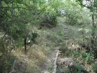
The side trails off of the main loop are more overgrown, such as the Wildlife Trail shown here.
One final "trail" is the service road that runs from the trailhead and arcs its way to the two ponds found along the main loop. This is a wide, rocky jeep trail that is not without its own merits, though the lack of shade on a sunny day made the going a bit rough as the temperatures rose.

In all I was able to squeeze out about 4.75 miles along the trails. The official tally for the park is five miles, two of which is a concrete loop not documented in this writeup and three for the nature trails. In three hours of hiking I only saw two people on the trail, and they were park workers on a cart near the trailhead. This trail is one of the best, if not the best, hike in eastern Travis County. It's got a couple of decent views, well maintained trails, descent terrain and solitude. I know that I'll be back.


(Photo by Marzieh)
Southeast Metropolitan Park

Good view of Austin from here. (Photo by Sleepindog)

Logs

Have you visited this location? What did you think of it? Submit your own log entry to let others know of your experiences and to keep track of your adventures.

January Hike 2010
User: Piedra - 1/11/2010  [View Log Page]
Rating: Difficulty: Solitude:
Distance: 2.50 Miles Duration: N/A

Hiked the trail with another family, six of us total, and the trail was a little soggy, but overall the hike was good. Did not see much, as far as wildlife, but the trail was clear and the views of the city were great.

User: Sleepindog - 3/21/2009  [View Log Page]
Rating: Difficulty: Solitude:
Distance: 2.50 Miles Duration: 1 hour, 30 minutes

Did the loop, some geocaching. Had an armadillo run in between my legs. Nice hike, great views! 2 nice little lakes that I didn't know existed.

close in but a good getaway.
User: seamonkey78704 - 2/22/2009  [View Log Page]
Rating: Difficulty: Solitude:
Distance: 2.20 Miles Duration: 2 hours

I think i may start going here once a week and running the trail. It's a nice mix of up and down hills, even if it winds around a little bit, and feels really short.

I really dislike the trail markers. Every 200ft is one telling you your exact progress, and making it impossible to imagine even for a few minutes that you're lost. I can see why others will like them, but really... its a closed loop hiking trail. Do we really need a numbered marker every 60 seconds?

The trail is very narrow, and feels more isolated than it really is, if you can ignore the low rumble of the city's auto and plane traffic. Unlike some other trails further out, that never really goes away here. On a bright, sunny Sunday afternoon, there were half a dozen cars in the parking area and we passed or saw around five or six other couples on the trail. A pleasant indication of the newness of the park and the fact that it hasn't registerd on most people's radar yet.


User: Marzieh - 6/12/2007  [View Log Page]
Rating: Difficulty: Solitude: N/A
Distance: 2.00 Miles Duration: N/A
Nice park but not the best I've been to. We were a group of 15 who went to the hike and when we came back we had all been bitten by some insect which made us itch and scratch our legs for one whole week.
Enjoyable but a bit muddy
User: christiniprosperity - 4/2/2007  [View Log Page]
Rating: Difficulty: Solitude:
Distance: 3.00 Miles Duration: 1 minute
I liked this hike. It really got my heartrate up. The 'rustic trail' was awesome because it felt like I was out exploring back in the day, except for the trail markers and the bridges. I only saw one pair of female hikers besides me. It was almost too secluded! I did enjoy the gardens and the vantage points sprinkled through out. And a few of the trails that dead-ended did so in really beautiful vistas. It was really a nice hike all in all.
User: lancescape - 11/25/2006  [View Log Page]
Rating: Difficulty: Solitude:
Distance: 4.00 Miles Duration: N/A
I walked the 2.5 mile loop.
User: Donald Bos - 5/28/2006  [View Log Page]
Rating: Difficulty: Solitude:
Distance: 2.50 Miles Duration: N/A
My son was playing soccer at the park and I decided to check out the trailhead and see if I could get some exercise in. I loved it and was surprised to see such a trail in the area especially the fact that it seemed fairly isolated. The trails were definitely rugged for me; I am 52 and overweight. I hadn't been walking much over the last several weeks and so experienced a sore knee, which eventually worked itself out; shin splints, which also eventually subsided, though not so quickly as the sore knee; and lastly I felt some fatigue with which I can survive if I just gut it out. All I mean is that overweight 52 year-olders should beware. All in all I loved this trail. I observed a pair of cardinals following along as their fledging went from tree to tree. That was a treat. We see baby blue jays and mockingbirds all the time in our neighborhood, and though we see cardinals from time to time in the yard, I take it they try to find more secluded areas to nest.
Quiet hike, solitude not much traffic
User: eezra - 4/8/2006  [View Log Page]
Rating: Difficulty: Solitude:
Distance: 3.00 Miles Duration: N/A
Several nice ponds and bridges, a couple areas of steep natural stairs.
User: rad707 - 3/25/2006  [View Log Page]
Rating: Difficulty: Solitude:
Distance: 2.80 Miles Duration: N/A
Well groomed hike; however, I'm not sure why they chose the route that they did. The only view you get of Onion Creek is from the primitive camping trail. Hopefully they will add more trails to this park as it is the best thing available on the East side of Austin.
User: Haleyms - 1/28/2006  [View Log Page]
Rating: Difficulty: Solitude:
Distance: 2.40 Miles Duration: N/A
A wonderful, beautiful trail
User: Haleyms - 1/15/2006  [View Log Page]
Rating: Difficulty: Solitude:
Distance: 2.70 Miles Duration: N/A
I was very impressed with this trail. There are markers all along the trail, bences to rest, and beautiful scenery. I saw 3 other couples along the way, but besides them, it was very quiet and tranquil.
Very enjoyable
User: donajo - 11/12/2005  [View Log Page]
Rating: Difficulty: Solitude:
Distance: 2.20 Miles Duration: N/A
It was pretty in the fall, but I'd bet it would be even prettier in the spring, when all of the trees have leaves. I went on a Saturday morning, and there was no one else on the trail and no other cars in the parking lot.
Nice trail, but...
User: golfnut4u - 11/1/2005  [View Log Page]
Rating: Difficulty: Solitude:
Distance: 5.00 Miles Duration: N/A
Returned to the parking lot to find my car stereo stolen. Car window had been pryed open enough to unlock door, and they then disabled the door sensor for my alarm (apparently). There had been 1 car in the lot when we arrived, and we only saw 1 hiker/exerciser (don't know if either was related to the incident). My car was the only one in the lot when we returned 3 hours later. Reported to the Rangers, but they hadn't seen anything going on. Big time bummer! The trail was nice, but fairly muddy due to the rains yesterday. There is a significant stench around the majority of the trail. Is there a sewage treatment plant nearby?
Very nice trail for the fall
User: figment - 10/29/2005  [View Log Page]
Rating: Difficulty: Solitude:
Distance: 2.80 Miles Duration: N/A
I did the loop hike and the wildlife spur. The trail markers every 200 feet are a very nice touch other parks in the area should copy. The wildlife spur needs to have some of the vegetation trimmed back however.
A hidden gem
User: Austin Explorer - 8/14/2005  [View Log Page]
Rating: Difficulty: Solitude:
Distance: 4.74 Miles Duration: 3 hours
I didn't hike the concrete hike and bike trail loop on this outing, just the nature trail portion on the northern end of the park. It was surprisingly rough and hilly with a couple of pretty decent views of downtown Austin. I only saw two people during the entire hike of 3 hours and that was very near the trailhead as I was finishing up. This could very well be the best hiking in Travis County east of Austin and maybe all of Travis County east of the Balcones fault line.

I saw no less than six different rabbits in the park and even a raccoon (not that common a sight during the day).


Recommended Item

Recommended Item 60 Hikes within 60 Miles: San Antonio and Austin (60 Hikes - Menasha Ridge)
by Tom Taylor, Johnny Molloy
List Price: $15.95 Our price: N/A Buy Now
Packed with valuable tips and information, 60 Hikes within 60 Miles: Austin and San Antonio gives you everything you need to get started. First, learn about the area's hiking possibilities and the author's opinions about the best places to go. Then, consult the author's recommendations for special interest hikes--wildlife hikes, historic hikes, hikes for families, and more. Each hike profile provides essential details on length, hiking time, difficulty, solitude, and more. The author also includes personal notes on the hike, a detailed hike map, and clear directions to the trailhead.