[ Log In ] or [ Register ]
Austin Explorer

Balcones Canyonlands NWR - Doeskin Ranch

Trail (3.97)
(2.84) (3.93)
3.70 Miles 510 Feet
N/A Yes
No No
Free More Info
Liberty Hill Burnet
Take Action Bookmark and Share

Getting there: From Austin, head north on US 183 to Cedar Park. Turn left onto FM 1431 and continue through Janestown and Lago Vista. Turn right onto FM 1174 and head north for 5.6 miles. The entrance to the preserve will be on the right.

The Hike: Doeskin Ranch is part of one of the newer National Wildlife Refuges. In an area of 80,000 acres, the U.S. Fish and Wildlife Service hopes to acquire at least 46,000 acres to preserve habitat for the area's endangered species. A side benefit of this important work is the wonderful trails that we get to enjoy.

Of the two trail areas open within the refuge, Doeskin Ranch is the largest in terms of trail length (The other trail is Warbler Vista, near Lago Vista). In all there are about 3.7 miles of trails, broken up into three loops of various sizes. Since the total length of the trails is less than 4 miles, all three loops can easily be done at once.

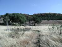
Doeskin's hikes begin on a prairie bottomland. One of the trails leads up to the hilltop pictured above in Autumn colors.
Rimrock Trail: We started our hike at the waypoint marked "Trailhead". Here you'll find a restroom and a few notice boards and interpretive guide holders. Our plan was to tackle the harder loop first, which the preserve calls the Rimrock Trail. From the trail junction point at the trailhead we head southeast, in the general direction of the hill that overlooks the parking area.

At the top of the hill the trail loops around a pocket prairie.
The trail crosses a small creek, the Doeskin Branch and then turns to the east with a more direct line uphill. Although parts of the hillcountry can be quite steep in small segments, there are not too many places where one finds switchback trails. Yet here they are. The erosion dampening twists and turns reminded us just a little bit of our trip to Big Bend a couple of years ago.

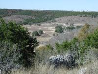
Looking down the hill to the Doeskin Ranch entrance.
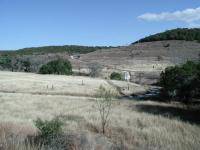
When cresting over the top of the hill the sky opens up as the Cedar gives way to a small prairie. The trail loops around the mesa-like hilltop. A portion of that loop is called 
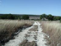
the Shin Oak trail by the Refuge. The trail descends down a few more switchbacks, eventually joining an old jeep trail that was used when the land was a working cattle ranch.

Descending down the hill and heading back to the trailhead.
The Rimrock Trail is the most difficult hike at Doeskin and accounts for Doeskin's overall rating. Rewards often accompany work and that's the case here as this particular loop provides the best views and most solitude in the refuge. We did not see another person on this portion of our hike.

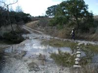
A couple of stream paths are easily traversed with stepping stones.
Creek Trail: This loop, like the others, begins at the Trailhead waypoint. It's doubly important to start this loop at the trailhead, since the interpretive guides are found here and hiking the trail in a clockwise direction will ensure you encounter the markers in their intended order.

This storage shed testifies to the land's prior use as a ranch.
The Creek Trail heads northeast from the trailhead, is relatively flat and covers about .6 miles. The building near the start of the hike was most likely used to store corn and other goods. The trail loops around, darting between segments of woodland and prairie.

About half of the trail parallels the Doeskin Branch creek. As the interpretive guide states, much of the creek's year-round flow can be attributed to small springs along its banks. Dry spots upstream and gushing segments downstream indicate the location of some of the springs, even though if they are heavily covered by vegetation.

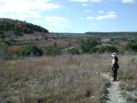
Looking uphill at the trail just hiked. Doeskin Ranch includes an interesting mix of prairie and Juniper-Oak brush, a bit more natural than much of the Hillcountry these days.
Pond & Prairie Trail: This trail is the easiest of them all and covers a scant .4 miles. Suitable for people of all ages, it circles a small pond and provides a nice observation point from which you can view the combination of prairie and woodland that the refuge is trying to maintain.

Overall: What a great surprise! On a beautiful, pleasant day, we almost had the entire trail to ourselves. We encountered a total of two people and both of those were walking the trails near the trailhead. The solitude was enhanced by the relatively quiet surroundings. The best vista at Warbler Vista overlooks the busy FM 1431. Here, there are few cars to disturb the peace. I can see why the birds like it.

Photos

Just past the trailhead Just past the trailhead (Photo by Riff Raff) First creek crossing First creek crossing (Photo by Riff Raff) Ascending Rimrock Trail Ascending Rimrock Trail (Photo by Riff Raff)
Start of Indiangrass Trail Start of Indiangrass Trail (Photo by Riff Raff) Rock cairns mark Indiangrass Trail Rock cairns mark Indiangrass Trail (Photo by Riff Raff) Pink flowers in Indiangrass area Pink flowers in Indiangrass area (Photo by Riff Raff)
Indiangrass Trail area Indiangrass Trail area (Photo by Riff Raff) Indiangrass Trail Indiangrass Trail (Photo by Riff Raff) Descending Shin Oak Trail Descending Shin Oak Trail (Photo by Riff Raff)
Second Creek Crossing Second Creek Crossing (Photo by Riff Raff)

Log Entries

Nice secluded hikes
User: jtkatie - 7/4/2010  [View Log Page]
Rating: Difficulty: Solitude:
Distance: 3.00 Miles Duration: 3 hours

My wife and I visited Balcones Canyonlands NWR looking for a nice long moderatly-challenging hike. So, we set off on the most difficult of the three loops: Rimrock Trail. We headed right at the 'trailhead', instead of crossing the river and going clockwise around the loop... Big mistake. After about a half mile, the trail grows very narrow and very grown over (nothing like the posted pictures). We ended up turning around as our legs were getting torn up by the growth and we could not see our feet (and did not want to end up stepping on a snake).

After backtraking to the beginning, we took the Creek Trail from the same trailhead area as the Rimrock Trail. Unfortunately, this was backwards for the interpretive trail, so we didn't get to pick up the guide until we finished the trail. Still a nice and peaceful hike. Saw and heard quite a few songfull Summer Tanagers.

After finishing the Creek Trail, we tried the Rimrock Trail going clockwise (crossing the river at the jeep trail). This was a much better experience and we easily climbed to the top (a few hundred feet elevation climb), which gave us spectacular views back down towards the prarie. After spending some time at the top, we headed back down the same way. We finished the day with a stroll around the interpretive Creek Trail.

Do note, there is absolutely no cell phone service in the area. You are on your own if you have any problems, want to check the radar, etc. Also, we did not see a human soul there the entire time.

good hike but too hot
User: sandew - 5/30/2010  [View Log Page]
Rating: Difficulty: Solitude:
Distance: 3.70 Miles Duration: N/A

mistake starting out at 11am didn't finish until 1:30, ran out of water and the heat was too much for the un-treed outer loop (Indian grass).  Only wildlife out in the heat was a few lizards.  Glad the creed was there on the trip back as we got our sweat cloths wet to cool us off.

There were lots of  wooden signs going out to the last loop.  Found a lot of rock markers along the Indiangrass loop, but as we exited that loop, there were no signs to go left or right to connect to the loop back to rimrock.  We went left, but right probably connected too...it was hot and we were tired, so the shortest route would have been nice.  Needed tio print out the map next  time.

Will do this again next fall/winter when it's cooler.

Outer loops
User: Riff Raff - 1/23/2010  [View Log Page]
Rating: Difficulty: Solitude:
Distance: 4.50 Miles Duration: 3 hours, 30 minutes

Hiked all of the outer loops today (Rimrock Trail, Indiangrass Trail, and Creek Trail). Only saw one other group out on the trails.

Nice quiet and peaceful
User: raidium - 4/19/2009  [View Log Page]
Rating: Difficulty: Solitude:
Distance: 5.00 Miles Duration: 3 minutes

The wife and I hiked this one today. We did all of the trails and only came across 2 people all day. When we arrived there were 2 cars in the parking lot. Ours and a mini van. When we finished up for the day and made it back to the parking lot there were about 6 cars but we only saw the one couple out on the trail.

The trail is very well marked and easy to follow. There are a few elevation changes that offer nice vistas. Benches have been placed at the top of the more demanding parts to give a nice place for a rest or quick lazy snack. 

We went after a stormy period and all the trails were still very accessable. Not too muddy. The breeze blows through the hills making the open grassland part of the hike very nice. We were able to spot several animal tracks and for bird watchers there are tons around. 

Overall, very nice, secluded and easy to hike.  

Hidden Gem
User: bspross - 2/22/2009  [View Log Page]
Rating: Difficulty: Solitude:
Distance: 4.65 Miles Duration: 1 hour, 30 minutes

This hike is a hidden gem in Austin.  We got there about 10:45 and there was only 1 other car in the parking lot.  We did all of the different trails.  Rimrock, Indian Grass, Shin Oak, Pond and Prarie and Creek trail.  The best one is Indian Grass.  It is an up and down and then across a pretty open hilly field.  I loved it.  Make sure you add to the rock cairns. 

When we left there were more cars in the parking lot, but still very tranquil.  This one would be extremely hot in the summer so if you go in summer, be careful.


Brian Spross

www.stuffpeopleread.com

User: claireBGC - 11/25/2008  [View Log Page]
Rating: Difficulty: Solitude:
Distance: 4.00 Miles Duration: N/A

One of my favorite places to hike in CenTex.  I've been several times, both spring and fall.  If you go at the right time, the oaks that are sprinkled in the woodland area circling the top of the hill are a really pretty red - mid to late November.  Saw quite a few birds, too.  Most of it is unshaded, so in summer I would definitely make sure to bring a hat. 

Rimrock Trail
User: nurse4rocks - 8/10/2008  [View Log Page]
Rating: Difficulty: Solitude:
Distance: 2.50 Miles Duration: 1 hour, 14 minutes
Quiet Monday Afternoon
User: Riff Raff - 7/7/2008  [View Log Page]
Rating: Difficulty: Solitude:
Distance: 4.50 Miles Duration: 3 hours

Hiked the outer (outer) loop of the Rimrock / Shin Oak / Indiangrass Trails, along with a bit of the Creek Trail before aborting as the rain came in.  Saw only one pair of people on the Rimrock trail while I was there.  Lovely area.

User: LVX - 3/15/2008  [View Log Page]
Rating: Difficulty: Solitude:
Distance: 5.00 Miles Duration: 3 minutes
User: dawnosu - 7/18/2007  [View Log Page]
Rating: Difficulty: Solitude:
Distance: 2.60 Miles Duration: N/A
I really enjoyed this hike. I never knew there were so many speices of grasshoppers. They were everywhere. There are some good inclines and declines, enough to get your heart pumping. The grass was knee-high in some areas but we have had a lot of rain. I took my shoes off and walked through the creek at the end. It was great! There is a beautiful waterfall. I saw a small frog, fish and a tadpole. I didn't see anyone except when I was in my car leaving. Another car came into the parking lot.

Only showing last 10 log entries. View All Log Entries

Recommended Item

Recommended Item Audubon Guide to the National Wildlife Refuges: Southwest: Arizona, Nevada, New Mexico, Texas (Audubon Guides to the National Wildlife Refuges)
by Daniel Gibson
List Price: $19.95 Our price: $7.94 Buy Now
The southwestern United States--in this case, Arizona, Nevada, New Mexico, and Texas--harbors several dozen federally administered wildlife refuges, 31 of them open to the public and profiled in this guidebook. Some of the refuges, such as New Mexico's heavily visited Bosque del Apache, are stopovers for great numbers of birds (in this instance, more than 17,000 sandhill cranes alone) and residences for diverse plants and animals. Others, such as Texas's 3,500-acre Attwater Prairie Chicken National Wildlife Refuge, are devoted (but, of course, not limited) to a single endangered species. Natural-history writer Daniel Gibson gives a thorough description of the region's wildlife refuges and of the wildlife they shelter, providing a guide that nature-minded visitors will want to have on hand when visiting the desert country. --Gregory McNamee