[ Log In ] or [ Register ]
Austin Explorer

Round Rock Memorial Park

Trail (2.30)
(0.83) (1.33)
0.50 Mile N/A
N/A No
Yes Yes
Free More Info
Round Rock Williamson
Take Action Bookmark and Share

Getting there: From the I-35 service road in central Round Rock turn east onto Sunset Drive and then right on Summit Street, heading south. The road will cross the creek and the parking area is on the right on the opposite side of the creek.

The Hike: Round Rock Memorial Park's trail system has its highs and lows. It spends a good deal of time passing under the concrete ribbon that is I-35. However, venture out to either end of the trails and you'll either find yourself lost in the vegetation or encountering local history.

Round Round Memorial Park's official trails are all paved.
The trail begins at the main parking area for the park marked by the waypoint "Trailhead". Here there are numerous picnic benches and a large number of ducks and geese just waiting for a handout from visitors. The area is well covered by trees and is actually somewhat tranquil, even with I-35 just a stone's throw away. The terrain for almost all of the official trail is pavement, so conditions even after a rain shower should not be an issue.

This foot bridge provides an easy crossing of Brushy Creek.
At several spots in the park bronze plaques provide a bit of history about the area's geography and the people who lived in the area, both before and after the appearance of European settlers.

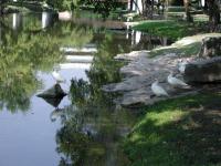
Brushy Creek as it cuts through central Round Rock.
The trail heads west, along the south shore of Brushy Creek. It passes under I-35 and then crosses the creek on a foot bridge paralleling the Interstate. Don't be confused by the topo map of this hike, which predated the I-35 expansion over the creek. The bridge actually passes under the I-35 service road bridge.

The numerous ducks are a big draw at the park.
Once crossing the creek head west again along the north shoreline. Look in the bed rock of the shore for parallel groves coming from the creek. That's not a natural formation. Rather, it's wagon ruts from the thousands of wagons that crosses here as part of the Chisolm Trail.

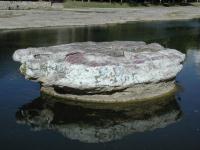
The Round Rock served as an important marker for cattle drive crossings.
A little further west, next to a road that crosses the creek sits The Round Rock. This formation, though not graniose, played a large role in the development of the area and is the reason for the city's name. The rock formation happened to reside next to the best creek crossing in the area, so it served as a useful guide.

The unofficial maverick trail to the east is rougher and more overgrown, but also provides more solitude.
The trail doubles back to the foot bridge and continues to the east on the north side of the creek. After passing under I-35 again you'll pass by the back porches of apartments that sit right on the edge of the park. The trail continues to a road that crosses the creek and turns back to the trailhead.

Optionally, you can explore an unofficial portion of the trails by crossing the road at the trailhead and continue east along the outfield one of the ball parks. You'll find the trails here largely overgrown and unfortunately also fairly well covered in litter. However, there are some places of quiet solitude that stand in contrast to the buy park and even busier Interstate a short distance away.

Photos

Log Entries

Nice little park with lots of history
User: texaskdog - 4/6/2010  [View Log Page]
Rating: Difficulty: Solitude:
Distance: 2.00 Miles Duration: 47 minutes

Map is accurate but at the west end you can go past the RR track.  Cross the road bridge on the west and you can hike further up the SW side.  Great to see the old wagon tracks.  There are some unidentified piers by the road that I am curious about.  Most historical park I've been to thus giving this small park 3 stars!

User: Kayla - 11/9/2007  [View Log Page]
Rating: Difficulty: Solitude:
Distance: 0.50 Mile Duration: N/A

A lot of traffic noise. Great historic interest because of the round rock and the wagon wheel tracks in the creek bed. Take bread for the ducks, especially early morning (they lose interest as the day goes by) 

Cute little park under IH 35
User: spacecitygirl - 1/25/2007  [View Log Page]
Rating: Difficulty: Solitude:
Distance: 0.50 Mile Duration: N/A
This is a nice, little park in Round Rock. The trail forms a loop around the creek, and is mostly concrete. The southeast side of the trail, near the parking lot, has many picnic tables, and a playground for the kids. There are a few plaques to read in this area too. I enjoyed eating a snack by the creek, and watching the ducks bob under the water to look for food. The east side of the park is bound by a low water crossing. If the water is too high, you will not be able to cross over it. The west side of the park takes you under IH 35, and toward the round rock, that Round Rock is named after. This part of the trail has a plaque that marks the Chisolm Trail, where many cattle drives went through. This is an enjoyable little park, with personality. I recommend it for a quick trip. It won't take you very long to go through and see all the sights in the park.
Bagging some caches
User: Austin Explorer - 5/20/2006  [View Log Page]
Rating: Difficulty: Solitude:
Distance: 1.00 Mile Duration: 43 minutes
Stopped by this park again to find three geocaches in the area. Ended up walking a mile in the process. Lots of people there enjoying the nice weather.
Nice central park with ducks
User: Austin Explorer - 8/16/2003  [View Log Page]
Rating: Difficulty: Solitude:
Distance: 1.10 Miles Duration: N/A
The path is completely paved, with the exception of a short spur trail. I-35 passing overhead adds some noise, but the creek is nice with ducks along the banks.
Hidden Park
User: Centex Trekker - 6/7/1998  [View Log Page]
Rating: N/A Difficulty: Solitude:
Distance: 0.50 Mile Duration: N/A

Only showing last 10 log entries. View All Log Entries

Recommended Item

Recommended Item Hill Country (Hill Country (Lone Star Guides))
by Richard Zelade
List Price: $17.95 Our price: $10.58 Buy Now
This book features ten tours to Central Texas that capture the essence of its flavor and charm. Take a ride on the Fredericksburg & Northern Railroad, follow the historic Mormon trails from Travis Peak Community to Medina Lake, visit Enchanted Rock, explore the Balcones Fault, and much much more.